So with our last day in the area upon us, we were unsure what to do, where to go. I suggested that we head north on highway 89 and get a few pictures of Mt. Shasta, then come back to Burney to eat, visit Burney Falls one last time, and that would be our day.... Well, that was the plan, but we had a wonderful surprise upon the way, and never did make it to Burney Falls due to some rain which had moved into the area.
It was a 50 mile drive to a vista area where we could see Shasta. At around the 40 mile mark, it laid there in front of us on the highway...but we quickly saw that it was shrouded in clouds. However, it is still a wonderful mountain to gaze upon.


Well, with nature calling me...I decided to travel on to McCloud, which was just a few more miles down the road. Here, I got this shot of Shasta.

Since I had entered onto a residential street to get the above shot, I figured we might as well look more into this quaint little town. We quickly found the downtown area....


This is a quote from the Chamber of Commerce website: "In 1965, U.S. Plywood transferred town properties to John W. Galbreath and Co. whose job was to help company towns make the transition to privatization. The houses were then sold to the people living in them. The McCloud Community Services District was formed and the utilities, such as water, sewer and street lighting, were turned over to the district. They also assumed responsibilities for fire and police protection, library services and some road maintenance."

Of course, if you needed to move lumber, you needed to have a railroad, and the McCloud Railroad started in 1897 and ran until the 1990's. It even had passenger service until the 1950's. The above railroad cars are on display in the main business district.
We enjoyed the quick tour of McCloud, and headed back toward Burney Falls....and then I saw this sign about McCloud River and something about lower falls. If there are lower falls, then there must be an upper falls too. In this case, there was also a middle falls.
We went to the lower falls area, but the pathway was questionable for the scooter. I thought I had seen a sign on the way towards McCloud which said something like "McCloud River Loop". So we turned onto the loop road, and quickly found the parking lot for the Middle Falls. It was paved, and the scooter would not have a problem with it. And oh, we were surprised! What a lovely area....I told Marcia as we parked that it was going to be a lovely sight....don't know why, but I could just feel it.
 Above is the water coming to, and down the waterfall, which is hard to see since it runs parallel to where we were. Below the river runs down the lovely, peaceful canyon.
 Below is a better view of the falls, which drops 50 feet to the pool below. It is the most splendid of the three. We did not go to the lower falls because when I asked one of the few groups of people in the area, they said it was the least spectacular of the three, and harder to get to.
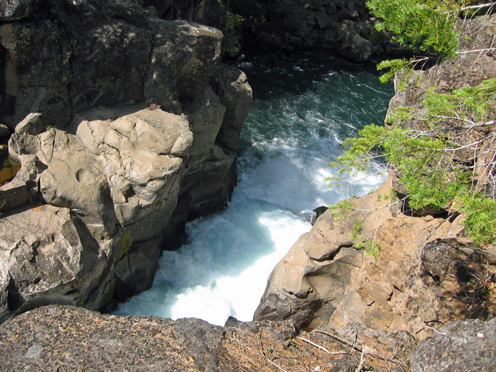
 We loaded up Skruffy and Bubba and headed to the upper falls, which is less than a mile up the road. It is probably a real nice water fall, but getting a view of the full length of the five falls which make up the water fall is hard to see. However you can feel the power of it as it shoot out from the overlook, and speed of the water at this point is unreal.


The three pictures above show the water moving from left to right, with the last one being the where the water pours out over the upper falls and drops 25 feet to the river below.
Wow, what a surprise we had...a wonderful river, two water falls, and view of a majestic mountain, even if the top was hidden behind the clouds. After our drive back to Burney to get a bite to eat (it was a good lunch two days ago, but tonight's dinner did not hit the mark), it was only the weather that stopped us from another quick visit to Burney Falls. Later research showed that the McCloud railroad had a line that ran right to Burney, and the bridge over Brinton Lake which the Burney River runs into a short distance past Burney Falls.
It has been a nice week, and it will be nice to be back with family after our drive back to the Sacramento area on Friday....while we head down, many campers will be heading up into these wonderful mountains to enjoy nature.
We enjoyed the quick tour of McCloud, and headed back toward Burney Falls....and then I saw this sign about McCloud River and something about lower falls. If there are lower falls, then there must be an upper falls too. In this case, there was also a middle falls.
We went to the lower falls area, but the pathway was questionable for the scooter. I thought I had seen a sign on the way towards McCloud which said something like "McCloud River Loop". So we turned onto the loop road, and quickly found the parking lot for the Middle Falls. It was paved, and the scooter would not have a problem with it. And oh, we were surprised! What a lovely area....I told Marcia as we parked that it was going to be a lovely sight....don't know why, but I could just feel it.


Above is the best shot of the upper falls one can see from the safe pathway, and I was smartly forbidden from trying to lean over the rocks between the pathway and the river to try and get a better shot. :)


The three pictures above show the water moving from left to right, with the last one being the where the water pours out over the upper falls and drops 25 feet to the river below.
Wow, what a surprise we had...a wonderful river, two water falls, and view of a majestic mountain, even if the top was hidden behind the clouds. After our drive back to Burney to get a bite to eat (it was a good lunch two days ago, but tonight's dinner did not hit the mark), it was only the weather that stopped us from another quick visit to Burney Falls. Later research showed that the McCloud railroad had a line that ran right to Burney, and the bridge over Brinton Lake which the Burney River runs into a short distance past Burney Falls.
It has been a nice week, and it will be nice to be back with family after our drive back to the Sacramento area on Friday....while we head down, many campers will be heading up into these wonderful mountains to enjoy nature.
No comments:
Post a Comment
We love to hear comments from our readers. All comments are moderated by Dave before added to the website. Spam, advertisers and rude comments are deleted, and due to high spam attempts, Anonymous Users can post, please register for a Google ID, it is free and it is easy. Go to: Get Google ID