Saturday, July 27, 2019

What Is It About Huntley Park?

At Huntley Park, Gold Beach Oregon

Huntley Park along Rogue River

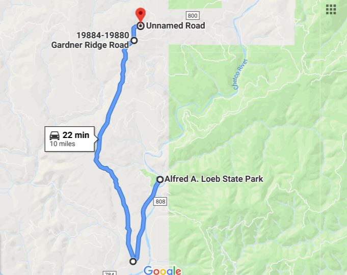
View of Huntley Park from other side of Rogue River as Jet Boat goes by

This is our third year coming to Huntley Park.  Like Loeb State Park, we just love this little place.  WHY?  Just BECAUSE is one answer.  The WEATHER is another answer.  The PEOPLE who work here is another.  The PEOPLE who gather here is another.  The VIEW is another.  The QUIETNESS is another.  Other than some flies, the LACK OF BUGS is another.  Also, being a day's drive from Sacramento area is another big plus!


Above is a panoramic view of Huntley Park from the other side of the river.  A road runs along both sides of the river from Highway 101 up to Lobster Creek, where the north side (the park is on the south side) road crosses Lobster Creek Bridge and ends…except for a few Forest Roads.  You can see Huntley Bar, with all the river rocks, and yes, you can drive down there.  At the far left of the picture, behind the brush in the foreground, is the beach that all those who want to swim, or launch a jet ski or a kayak from, is located.  Fishing boats sometime launch down there too, but more than likely they just pull up anywhere along the rocks, back the boat into the water, and they are off fishing.


The views to the east, up river.


Tried to get a picture of our motorhome, but we are under a tree, and the other trees block the view…awe shucks, but the arrow shows where we are.  No one can see us from the other side of the river which is a big plus...they can't see us means WE won't see them.

Now when I say it is quiet, I don’t mean there is never any noise.  EVERY TIME one of these suckers (tour boats) goes up or down the river, yes, you hear them.  However, it is not a obnoxious noise, and it lasts for perhaps a minute…slowly hum, then it increases to a noticeable louder engine noise, then it goes by, and soon just a low hum, then quiet again.  The 'RED' boats are louder than the smaller "BLUE" ships are.  Yes, there is traffic on both roads, but unless it is an 18 wheeler, you hardly notice.  The park itself gets a bit traffic coming and going, but again, not that bad.


To our right there is a string of smaller motorhomes and trailers…the first three or four with fishing boats.  The assistant camp host told me that they live in Grants Pass, and come over for the weekend to fish…they have been here for 3 weeks now.  So nearly $100 per week to sit there empty for 65% of the time?  Well, that makes it that much more quieter for us now doesn’t it, and so far I have only seen one person, and that was today.?


In fact, this year over 50% of the people camping at Huntley have fishing boats.  You can see a boat in each picture above, and there are a lot more than these five. The fishermen leave in the morning, sometimes return early afternoon, but it is not uncommon for them to return near dusk.  The Rogue River is in its early stages of a King Salmon Run.  The river water is still too warm, but at the mouth of the river, near the ocean, is where  the fishing is, and they are starting to catch them.

Not everyone uses a boat, and this guy is probably going for steelhead-trout.  He was right out in front of our motorhome, and was enjoying himself…

…until that Jet Boat pictured earlier went by and he suddenly gave up.  I have seen the Jet Boat operators pull up alongside fishing boats to try and get the fisherman to talk, but the only talking I saw was hand gesturing…showing the boat operator that he only had one friend in this world.


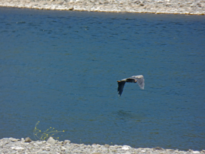
This Blue Heron was fishing too…and it took off as the boat approached.

As dusk arrives, I put away our solar panels each day.  So far, we have only run our engine for about an hour once.  The next day I decided that after two years I would fill the batteries to the proper level with water.  So I went down to the river, grabbed me some water, and filled them suckers up.  OK ARNY, YOU CAN CALM DOWN NOW!   I got some distilled water from the grocery store and did them right…each of the two batteries took about an 1/8th of a gallon, so I was a bit low.  Good thing is, the charge is much better.  Unless we hit an overcast day, we probably won’t need to use the engine to help charge them.

Wednesday, July 24, 2019

Huntley Park Along Rogue River

At Huntley Park, Gold Beach Oregon

Huntley Park near Gold Beach Oregon

Traveled over to Gold Beach and then up the Rogue River 7 miles to Huntley Park.  Huntley Park is under the authority of the Port of Gold Beach, and managed by Shawn and his wife Patti.  This is our third year being here, and they too raised their prices to $95 per week ($15 per day). We found a nice tree for shade during the afternoon, it is right across from the bathrooms which you can see in the background, and they have showers which cost $2.


We are facing the river this year, normally we have backed in.  You can see our solar panels out in the sun, and what is that in the window?


Oh it’s Bubba, and you can see Marcia in the background too.


Well, I think Bubba was just checking out the river view…or maybe he was wondering if he was ever going to be able to go outside again…


It was an easy driver over to Gold Beach.  Stopped at the Rest Area across from Harris Beach State Park north of Brookings to dump our tanks, and about 40 minutes later we were pulling into Gold Beach.  Down in Brookings the ocean view was null with ocean fog blocking out everything.  About 4 miles out of Gold Beach, it cleared up and we got a few ocean views.


I took a drive up to Lobster Creek National Forest Campground…$15 per night here too, but it is small, only 2 or 3 sites for small RVs and a number of tenting areas.  They do not allow you to camp on the river itself.


You can drive down to the river, and I drove part of the way down to get a picture of the Lobster Creek Bridge look upstream, and…


…here is a view looking down river from the the same vantage point.


But the views from up on the bridge (first looking down river) are the best, and in the bottom picture you can see the shadow of the bridge across the water.  In the top picture you can see Lobster Creek flowing into the Rogue River, hence the name of the area.


When I got back to the campground, I saw a number of Osprey flying high above the area.  One of them perhaps the one above, landed in the tree just on the other side of the HHR.


This closer view shows it up in the tree, and luckily for me, it stayed up there for a number of minutes.


Yep, I think we are going to like our third year at Huntley…sure starting off nice.

Sunday, July 21, 2019

Busy Weekend Calls for Another Drive

At Alfred Loeb State Park, Brookings Oregon

Chetco River up river from Lobe State Park

Friday evening I took Skruffy for a short drive up river to get another shot from the Bridge of the Chetco River.  The lighting was different than last time, and the river was not moving much to the tides, offering a good reflection.


"What did you think of that little girl?"
"Dad, you KNOW I can’t see…why even ask that question??"
First time I had taken Skruffy on a little trip in awhile…she loves to go in the car, but she just can’t see that well anymore.  I can NOW pull up next to another car with dogs inside of it, and she is oblivious to them.  If it is not a bright sunny day she sees better…the darker it is, the more she sees especially if the target (ie: another dog) has some illumination to it.  She will be outside in the shade with me here at the park, and she has seen people walking their dogs, and of course, Skruffy will be Skruffy and she will bark.  If it is just people walking by (or kids on bikes or skateboards), she gives a small moan in anticipation of barking IF she sees a dog with them.  But out on a walk in the sun, dogs have gotten very close to us and she smelled them, but otherwise did not know they were there.


Yesterday, with all the action here at the park, I decided to go on another drive…this time I went back towards Brookings, and turned north on Gardner Ridge Road.  I knew that Gardner Ridge would eventually lead back into another part of the Chetco Fire area, but I was hoping I might find a hill tall enough to see the ocean…but to no avail on that idea.  After about 7 miles on Gardner Ridge Road, there is a dirt road off to the left, which I also took.  Google Maps shows that dirt road ending fairly quickly, but I know I went up that dirt road about 3 miles before turning around.  My guess is that after the fire the road has been added to, and probably connects to another dirt road that is also on Google Maps, all for the logging operation to rid the area of the burned trees.


After four or five miles on Gardner Ridge Road, which by-the-way was a lovely drive up to the ridge with a few scattered homes here and there, I started to see some of the devastation from the fire.


Eventually it was right up to the road, and went over the road…

…and off it went towards the Ocean -- over this ridge, down the next and onward.  Thank goodness they stopped it before it took out the communities of Carpenterville and Pistol River, both of which did evacuate around August 20th because it looked like the fire wasn’t going to stop until it hit the ocean.  As I said before, they did lose about 6 homes…a few of them were probably further down Gardner Ridge Road than I wanted to travel...but Google Maps shows some homes down that way, but they have not updated their maps since the fire.


Above is a wide-angle view of the area looking to the east, and you can clearly see where they (the fire fighters) stood their ground and stopped the fire from heading a more southwestern course towards Brookings.  Had the fire been allowed to just burn, there is no doubt that Brookings and all the way up to Gold Beach would have been taken out. 


Driving further down the dirt road, which was headed in a north-easterly direction from what I could tell, I saw this line of what looked to be lost crops (see arrow).


But they were not crops at all, they were burnt, downed trees that the loggers had put into these rows.  (picture has been magnified and is not as crisp as I like). 


As I continued down the dirt road, I came upon some more rows of these trees lined up right alongside the dirt road.  The rows of downed trees continue right down the hill off from the road…but I did not feel adventurous enough to walk out there and take a picture looking down the slope.


Eventually I turned around on the dirt road and headed back.  Here is a picture of Gardner Ridge, with the arrow pointing to the communication towers at the top of the ridge, and you can see the Gardner Ridge Road going through that green patch just off center in the picture. While on the dirt road, I did not see another car.  While on Gardner Ridge Road, I passed a few cars going the other way...very light traffic indeed.

When I got back to the Chetco River Road, I turned right towards Brookings instead of left towards Loeb State Park because the dirt road took its toll on the HHR leaving it covered with dust.  As I awaited my turn at the car wash, I texted Marcia to let her know where I was and that I would be running later than my 3 pm estimated time of return.  One thing I did notice while driving the Gardner Ridge Road is there are at least two turnouts where we could park overnight “IF” we get shut out from getting back into Loeb State Park.  On Tuesday we head north 30 miles to Gold Beach, but we plan to return back to Lobe four weeks later.  That would give us another two weeks, taking us through the Labor Day Weekend before we start back to California.  Lobe has been very busy so we "could" get shut out for a day, but I plan to be here early enough to make sure that does not happen…but if it does, we have a few alternatives, and Gardner Ridge Road is just one of them.


Thursday, July 18, 2019

River View Trail – 2nd Week at Loeb State Park

At Alfred Loeb State Park, Brookings Oregon

Riverview Trail, Loeb State Park

Our first week at Loeb State Park was a bit different than the past three years…it was not busy until Friday.  One could have pulled in and grabbed a spot without any trouble. 

Riverview Trail, Loeb State Park

I was beginning to wonder if less people were traveling this year.  Well, Friday was full, and it has been full every day since then.  Tuesday (two days ago) all the spots were taken by 10 am!  WOW!  So now things are back to how I remembered it…I guess there was just a lull after the long 4th of July Holiday.

Chetco River, Loeb State Park    Chetco River, Loeb State Park
Chetco River, Loeb State Park

The picture above-left was taken last week…only one vehicle along the river.  Today, the picture above-right was taken, along with the larger picture below these two…a good dozen or more.  With day use being free, many locals from Brookings come up, along with people who are camping.  Yep, things are back to summer normal now.

Riverview Trail, Loeb State Park

Yesterday I finally did the River View Trail in its entirety.  I say “entirety” because two days after doing the Redwood Grove Trail, I walked about a quarter of the River View Trail just to get my legs going again.  Didn’t have a camera or even any water on that day…it was just a stretching of sorts.  Very quickly on the River View Trail you come upon the one and only bench ‘on the trail’.  At the start of the trail are a number of picnic tables, with many more at the day-use parking area nearby.  Yep, I used this bench…on my return.  Nice cool river breeze, shade, and peace and quiet from the folks down river swimming and listening to their boomboxes. 

Riverview Trail, Loeb State Park

The River View Trail is very gentle, wide enough path that you don’t fight the bushes, and that tree over the trail is an optical illusion…you don’t even have to bend your head to go under it unless you are 7’ tall.

Riverview Trail, Loeb State Park

Here is the first, smaller bridge passing over a dried up stream. 

Riverview Trail, Loeb State Park

On the bridge you can look up towards the roadway…but you can’t see it.  You can hear cars pass by if you sit there long enough, probably see the top of large trucks...but most of the path is free from the traffic noise.  That picture sure shows the thick growth within this Myrtlewood Grove.

Riverview Trail, Loeb State Park   Riverview Trail, Loeb State Park

It seems that there is always something to photograph along the trail…but I have to admit, the further I went, the less pictures that I took.

Riverview Trail, Loeb State Park

It is called River View for a reason…it has numerous river views, hindered by the thick brush most of the times.  But you typically get a nice river breeze to help keep you cool in the 78 degree temperatures.  (Oh, today hit 80, so we turned the AC on for awhile.)

Riverview Trail, Loeb State Park   Riverview Trail, Loeb State Park

Even halfway up the trail I saw a couple of vehicles (white car in upper left picture) along the river…both anglers, but I have no idea what they were after or if they got any.  Also, I saw numerous floating devices, like this yellow raft in the upper right picture.  (Remember, if you click on a picture you will see a much larger picture)

Riverview Trail, Loeb State Park

Here a dad and young son (I can only assume) were enjoying an easy, lazy float back down the river.

Riverview Trail, Loeb State Park   Riverview Trail, Loeb State Park

The only real hazard on the trail is this tree you ‘can’ go under if you choose…if you choose not to, than take the trail that leads ‘up’ and around it to the left.  I went under on the way, and above on the way back…it is not that steep and going under required me to brush cobwebs off my head.

Riverview Trail, Loeb State Park
When you get to the larger bridge, where the water passes through this pipe that you cross over with the bridge, you know that you are close to the end.  I like this bridge, it is a place to sit again!  Made it this far with just a few ‘lean on a tree’ moments, so I enjoyed a few minutes sitting after I crossed the bridge.  When I got to the road at the entrance to the Redwood Trail, I turned around, crossed the bridge and sat again for just a few minutes.  Made it all the way back to the bench shown in picture at the start of the trail where I took good long break.  Overall it was a nice, cool day, passed a handful of people (including one lady who looked to be in her 80’s…not sure they made it all the way), and it was just a wonderful hike.  Not nearly as sore as with the Redwood Trail, even though this is .7 of a mile one way, so nearly a mile and half round trip.  Today, my legs feel fine, but I do wish I had remembered to take my hiking stick (cane) with me...but when I realized I had forgotten it, I was already headed down the trail so I just continued on.  Didn't need it, but it would have been nice to have.

Today (Thursday) we took the motorhome into Brookings to dump our tanks again.  Tomorrow is laundry day, and Saturday, Sunday and Monday is something we will think about with the time comes.  We sure are enjoying our time here at Loeb State Park.  Thinking on staying here again on our way back to Citrus Heights...perhaps for the Labor Day Weekend...which means we might just come through a week early just to be sure we can grab a spot!

Monday, July 15, 2019

Checto Bar Fire – Two Years Later

At Alfred Loeb State Park, Brookings Oregon

Map of the 2017 Chetco Bar Fire

On July 12, 2017 the Chetco Bar Fire was first spotted, started by lightning.  A week later the fire had grown to 300 acres.  By early August, the fire had grown to nearly 3,000 acres, and then the wind took over.  By mid-August the fire had grown to over 20,000 acres, by August 24th it was over 100,000 acres.  It took into November before the fire was contained…burning over 191,000 acres.  That year we were here at Loeb Park from about the time the fire started through July 30th when we moved to Gold Beach.  We had not heard of the fire while we were at Loeb, but heard about it fairly quick once we got to Gold Beach.  Loeb is just northeast of Brookings (bottom left on above map)…Gold Beach is in the upper left.  By August 7th we were at Huntly Park northeast of Gold Beach.  By the 20th of August we decided the smoke was bad, evacuation notices were going out, and we decided to head north on Monday the 21st, then east to I-5, and eventually back to Citrus Heights.

2017 Chetco Bar Fire

Saturday I drove over 15 miles from the campground and never did come to the end of the fire zone.  The devastation of the trees reminded me of the many areas we have seen that have had fire damage before….Yosemite’s Rim Fire, Yellowstone’s 1988 fire, and many others.  
2017 Chetco Bar Fire

2017 Chetco Bar Fire   2017 Chetco Bar Fire

The ride gave me a good idea of the fire’s magnitude along the North Bank Chetco River Road and National Forest Road 1376, but I could see that the fire continued northwest over the various ridges.  At mile marker 15 I turned back, and that is when I started taking pictures, so many of the pictures are headed south and west…I can’t remember what direction I was facing for all of them...sometimes I got out of the car, sometimes I did not.

2017 Chetco Bar Fire

There were a few areas where loggers have gone in and harvested some of the damaged trees…and this is an ongoing process.  They won’t be able to harvest the entire 191.000 acres, but many acres will be harvested.  Above is a picture of tree stumps where they harvested already.

2017 Chetco Bar Fire

2017 Chetco Bar Fire    2017 Chetco Bar Fire

2017 Chetco Bar Fire

There are many parts along the river that show little to no damage due to the fire.  There are a number of National Forest Campgrounds along the river ($10 per night, $5 with senior pass), and other areas that are free for day use and some boondocking, which may or may not be legal along the river outside of campgrounds.

2017 Chetco Bar Fire

And yes, they park right up to the water.  The rocks along the bank are typically the size of a fist…some bigger, many smaller.  The bank is very hard…although the rocks will move, for the most part the rock bed is very hard, and cars, trucks, trailers move right along it.

2017 Chetco Bar Fire

Evidence of the fire can be seen within 2 miles from the campground.  Here, if you look close, you can see a few trees with fire damage among an area of good healthy trees.  In fact, I can see fire damage on the hill from our campsite on the other side of the river. (no picture of that)

2017 Chetco Bar Fire

The firefighters, once called out, valiantly saved certain areas along the river, and Loeb State Park was definitely one of them.  In the Gardner Bar area there’s around 20 homes which were saved, but 3-4 up on the hill were lost.  I am sure it helped that there was a huge fire break between the small community and the mountain the fire came down…but still, firefighters had to work to save homes from burning ashes.

The fire burned six houses, forced 5,000 people to evacuate their homes and threaten communities from Brookings to Cave Junction..it cost over 60 million to fight.  The strategy by the Forest Service was to allow the fire to burn out.  Other fires in the past had done so.  This one probably would have…except for when the Chetco winds added a blast-furnace of 45 MPH to the flames…things got out of control very quickly.

747 Super Tanker

This is a 747 Super Tanker…it can carry 19,000 gallons of water - and dump it all as fast as 7 seconds … just a few drops from it back in early July, and there would not have been a story.  

At Loeb State Park we were filled to capacity Friday and Saturday, but at 6:30 Sunday there were still 10 sites open.  The past two years we were here it seemed that the park was full just about every night.  Hey, not complaining, the less campsites being used, the quieter the park is.

Friday, July 12, 2019

Redwood Nature Trail – Loeb State Park

At Alfred Loeb State Park, Brookings Oregon

Chetco River near Loeb State Park

On Wednesday evening I took a ride up the Chetco River about a mile and a half where the North Bank Chetco River Road crosses the Chetco River.  As evening grows near, the shadows along the river can be interesting.  This first picture was taken just as I was exiting the park.

Chetco River 1.5 miles above Loeb State Park

I parked at the bridge and walked across it.  Above is a picture looking up river, while below…

Chetco River 1.5 miles above Loeb State Park

…while this picture is looking down river.

Chetco River 1.5 miles above Loeb State Park

Chetco River 1.5 miles above Loeb State Park

Look at how you can see right down to the rocks down in the river.  Looked for signs of fish, but did not see any…perhaps the birds of prey keep them away from waters like this.  Had a young Bald Eagle swoop right down in front of me the other day as I was driving around.  WOW, what a surprise that was!

Map of the Redwood Nature Trail, Loeb State Park

Well, on Thursday I decided it was a cool enough day to attack the Redwood Nature Trail, just north of the campground.  I discovered this hike last year, and I walked the Riverview trail a few days before the Redwood trail…but this year I decided to do the Redwood Trail first.  It is a mile loop (I know, the map says .9 of a mile, but when you walk from where you park to the red dot it adds up to a mile) with a gain in elevation by about 500 feet.  Last year I started to the left, this year I started to the right.

Redwood Nature Trail, Loeb State Park

Very quickly you cross over a bridge, and stand there listening to the quiet brook that flows down and under the bridge.  Through the entire hike I only saw a handful of people…it was very quiet.

Redwood Nature Trail, Loeb State Park

There is an abundance of plants, like one finds in many coastal redwood areas.  This particular coastal redwood patch shares its home with Douglas Firs, Maple Trees, and lots of plant life…

Redwood Nature Trail, Loeb State Park

…including Poison Oak.

Redwood Nature Trail, Loeb State Park

But you can see the path is wide, and I did not encounter (I hope) any poison oak growing onto the path.

Redwood Nature Trail, Loeb State Park      Redwood Nature Trail, Loeb State Park

Redwood Nature Trail, Loeb State Park

Redwood Nature Trail, Loeb State Park

One can really enjoy this trail.  In fact, I stopped numerous times just sit and listen to the peaceful sound, feel the cool air flow by, and pant like a dog laying out in the summer sun.

Redwood Nature Trail, Loeb State Park

When I came upon this nature-made chair just a third of the way, I thought I was in heaven! 

Redwood Nature Trail, Loeb State Park

Yep, look at that smile on my face.  I don’t take many selfies, but this one seemed appropriate…it is also the last one I took because here I was only 1/3 of the way done…the next third just about killed me.

Redwood Nature Trail, Loeb State Park       Redwood Nature Trail, Loeb State Park

Just about here (picture left) I hear this noise…a very slight rumble.  Suddenly this 50 year old female comes RUNNING down the path right at me.  “NO!”, I said, “IT IS NOT FAIR TO RUN!!!!”   She just laughs as she passes by me…my spirits are dashed.  By now I am soaking with sweat, she is as dry as bone.  Reminded me of when I hiked Pinnacle Mountain with a group of people in Arkansas as this guy runs up and down and up and down passing us many times.  THANK GOODNESS she did not run it a second time, I would have felt like a pea in one of those bounce houses at McDonalds.  In the picture right, I was hoping that I could make a bed along that fallen log…it was sure tempting.

Redwood Nature Trail, Loeb State Park

Near the end of the trail, I sat upon another log and just contemplated about how long it would take to myself to get back up off that log.  At this spot one can just get a slight cell signal, so I texted Marcia to let her know that I would not be too much longer.  It was all downhill from here, and a smooth trail…I don’t think I stopped much more than two or three more times with less than 2/10ths of a mile left.

Redwood Nature Trail, Loeb State Park 

A point of interest or two…here is a shot of a Douglas Fir and a Coastal Redwood.  They are both large trees, but their trunks are very different…with the Fir having large gaps in the bark (left) while the Redwood is a smoother look but a very splintery look.

Redwood Nature Trail, Loeb State Park

Near the end (or beginning depending upon which way you go) you will see this heavy cable.  It was was a logging cable, used to drag cut logs down off the mountain…err….hill. 

I made it back to the car, drove back to the motorhome, and sat in the car with the A/C going (on a 70 degree day) just to cool down a bit.  After getting into the motorhome, I sat for a bit after taking a couple of Aleve, and eventually made my way down to the showers (which they had parking at the showers so that I did not have to walk it!)  Now, 24 hours later, other than a little ache in my knees, I am doing fine.  Next week, the Riverview Trail, which is 3/4 of a mile to the entrance of the Redwood Trail, and 3/4 of a mile back.  The good thing, the elevation change is minimal.  The Redwood Trail, according to the Park’s pamphlet, is Moderate to Steep, while the Riverview Trail is Easy to Moderate.  After doing the Redwood Trail, I think the Riverview Trail will be pretty easy.