Showing posts with label Passport America. Show all posts

Tuesday, April 12, 2022

Lazy Days and Lazy Nights - Albuquerque, NM

First, we had to GET to Albuquerque New Mexico

Here is a look at the Double D RV Park that we stayed in at the Oklahoma-Texas Boarder.  Nice little park, and we had it all to ourselves.  $14 Passport America price.

It only took us a minute or two before we were into Texas.  Saw this cloud formation outside my window which looks very interesting.


The Texas Information-Rest Area is a typical "LARGE" Texas rest area.  Things really are bigger in Texas.  (Bigger does not mean better...) 

With the winds that are always in Texas, there are numerous windmill death traps along the highway.

The largest free standing cross in the western hemisphere, located along interstate 40 in Groom Texas. The cross,  erected in 1995, is 19 stories tall, and can be seen from as far as 25 miles away.


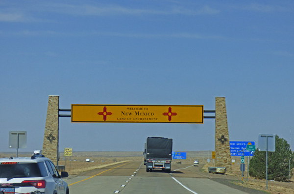
It only took a couple of hours, and a fill-up in Amarillo, to get into New Mexico.  

I-40 in Oklahoma/Texas/New Mexico follows what is referred to as the California Road (not the California Trail which is further north along I-80).  It was another route, not used as much, to the California Gold Fields.

The rest of the route in New Mexico was just full of wind.  I could not help but remember the time back in 2016 when our fuel pump went out along I-40 in New Mexico.  THAT was an experience we don't wish to relive...but the longer your RV the more likely something like that is going to happen again.

As I said yesterday, this if our fourth time at the Enchanted Trails RV Park & Trading Post.  They don't seem to have as many 'iconic' older cars and RVs as they did before...probably couldn't say no to a goo offer that someone made.  It is still a nice park, and there are still a lot of older RVs, cars, tractors, and other stuff.

Indy and I sat out in the wind, in the front of the motorhome which blocked most of the wind, for a good hour.  She saw some birds, a half dozen dogs, one of which was of the Pitt Bull bread, but she was very nice to anyone and anything that came by.  She wished the smaller dogs would have come closer, she would have loved to have played.

Here you can see her sitting on my lap, and the wind has blown her face pretty good.  Took her for a walk down the doggie walk and she did her business, so I won't have to worry about letting her out again at 2:30 am as I did last night.  Hard to drive so much and keep on a potty schedule.

Tomorrow will be laundry day, and more R&R.  Looks like we are on track to be in California sometime Sunday or Monday, God willing.


Monday, November 29, 2021

From Joshua Trees through the Mojave Desert to Needles, Ca


It did not take long to get over Tehachapi Pass, a mountain pass crossing the Tehachapi Mountains, a principal connector between the San Joaquin Valley and the Mojave Desert, also known as Highway 58 through the mountains. We left at 7 am, filled up at the Flying J in Tehachapi at $4.39 per gallon ($150 for 34+ gallons of gas) and soon we were in the western Mojave and coming into patches of Joshua Trees.


As I am passing by tree after tree I think about the many old Western movies and/or TV shows where they show Joshua Trees in places like Kansas, Montana, Colorado, even the Dakotas.  Fact of the mater is that the Joshua Tree is found primarily in California, and small parts of Utah, Nevada and Arizona....along with parts of north-west Mexico.  A similar occurrence happens with Saguario Cactus.  It is native to the Sonoran Desert in Arizona, the Mexican state of Sonora, and the Whipple Mountains and Imperial County areas of California...yet can be seen in episodes of Wagon Train crossing through Kansas or Colorado, various movies not set in Arizona, etc.  It's kinda like watching a movie of Custer's Last Stand with the background of Sedona or Monument Valley as the backdrop to the movie.  Back when those movies and TV shows were shot, they did not expect people to have the Internet or that so many would have the ability to visit these sites in person.

Here in the Mojave Desert the tree brings a bit of life to the dreary desert.  Let's face it, except for a few areas, the Mojave Desert is a bit of a boring drive.

We drive through the newly upgraded Highway 58 through Boron (all four lane, two each way now) and through Barstow, and hit the Rest Area just 20 miles east of Barstow...one we seem to stop at each time.

Seems we stop at the Desert Oasis Rest Area area going either east or west on I-40.

Above you can see the west rest area on the other side of the freeway.  Tears came to my eyes as I told Marcia that just 9 1/2 years ago the view was from the other side of the freeway...

Here they are, Skruffy and Bubba...looking at the east rest area right at where we are parked 9 1/2 years later, right where I put this red arrow into the picture.  Perhaps they knew something...or perhaps they were thinking just what I posted about this picture way back then.  "Who stole the #*%*@&* grass?"

Over the next 120 miles there are only a few distant mountains in which to enjoy, along with a few cactus species.  At 59 miles per hour, which is 4 miles over the speed limit but slow enough not to attract the attention of the three highway patrol officers monitoring the patch of highway, it is a long long drive...  


We finally make it to an RV Park we have stayed at many times before...Fender's River Road Resort in Needles, right on historic Highway 66, with part of the park right along the Colorado River.  It is a Passport America park and cost just under $20 for the night's stay.

As we drove the 'back way' to Fenders RV Park from the Interstate, we came across a number of rock displays, all with flags.  I told Marcia that I would need to unhook the car and come back to check it out...it is about a mile away from the park.


All of the displays seems to correspond to a Veteran's Day celebration.  There was a display for the Army, Navy (above), Air Force, Marines, and Coast Guard, along with a VFA display and this Vietnam POW/MIA display.  All together there was around a dozen displays.


The sun made it hard to get good pictures on the southwest side of the road, and threw shadows on the other side of the road.  It was a real special, inexpensive display of Patriotism that I really appreciated.

Tomorrow we will enter Arizona where the time changes by an hour, and gas prices drop by 25%.


Tuesday, April 30, 2019

Made It Through Tornado Alley

At Blaze-In-Saddle RV Park, Tucumcari, NM

Driving Through Tornado Alley


My biggest fear of our trip was the driving over the past two days…right through the heart of Tornado Alley.  Late April through early June is VERY BAD in the traditional Tornado Alley…and frankly, it was nothing I was looking forward to doing.  I have driven through Oklahoma in a car a number of times in May or June…and one time a tornado was just to the north of us, although we did not know for sure it was a tornado until the next day.  The new talk is that Tornado Alley now includes all or parts of Missouri, Arkansas, Mississippi, Alabama, Tennessee, Iowa, Illinois and even Indiana.  Well, we drove through some of those states too. But when we left the Kansas City area, we pretty much drove the area indicated by the blue line in the above picture.

4 Acres RV Park, Kinsley, OK

Our goal was to get to New Mexico by Tuesday night.  Monday I figured either Dodge City, or Kinsley, just shy of Dodge…both of which have Passport America parks.  I liked the park in Kinsley, so we pulled in there.  $19 cash for the night, full hookups, and a nice, quiet night’s sleep.  They anticipated some rain during the night, which never materialized, so I did pull the slide in before going to bed.  The drive to Kinsley was fairly easy, good weather, light traffic for the most part.  We got a pull-through site which, as you can see above, could have fit a 45 footer pulling a small car.

4 Acres RV Park, Kinsley, OK

A nice feature of the park is this area to walk/run dogs, and it includes a creek on the other side of those trees which can be hiked.  I walked the dogs, did not do the creek…temps were a bit cool, but not cold enough to wear long pants.

Blaze-In-Saddle RV Park, Tucumcari, NM

Today (Tuesday) we left 4 Acres Park by 8 am, drove to the Flying J in Dodge City to fill up and feed the dogs.  So far…so good…but it did not remain that way.  About 15 minutes southwest of Dodge, it started to rain…then hail…then hard rain…then heavier hail (but small hail balls).  For the next 2-3 hours it was white knuckle driving for much of the time.  Traffic was again fairly light, but we only go 60 mph, while the trucks and cars want to go the speed limit of 65-70.  About every 8 miles there was a passing lane, which was good.  However, some of the cars were not willing to wait, and a few passed on a solid yellow line.  Anytime anyone passed, I always pulled to the right line and slowed up a bit…for the solid yellow line passers, well let’s just say I only had to eat one bar of soap today mom.

Blaze-In-Saddle RV Park, Tucumcari, NM

So tonight we are at the Blaze-In-Saddle RV Park in Tucumcari, New Mexico $14.60 for full hook-ups at another Passport America park.  The park use to be named, “Empty Saddle”, but they wisely decided to change the name since the former name meant “The Rider Died…The Horse has an Empty Saddle”.  It is past 7 pm Mountain Time, and one Horse Trailer / RV is here, and the park is over two-thirds full with RVs still pulling in.  The sky is blue, a slight wind is blowing, it is in the mid-70’s, and we are thankful to get through Tornado Alley.   The Weather Channel (Weather.com) has this headline: 

Damage in Missouri, Oklahoma, Arkansas From Reported Tornadoes as Severe Weather Hits Plains

And within the story the following line:  “A potential tornado caused damage in at least three states as a rash of severe storms lashed the Plains Tuesday, spawning as many as 19 tornadoes across several states.”  

Yep, we made it through just in time…

Blaze-In-Saddle RV Park, Tucumcari, NM

The Dogs…well they are thankful for the Dog Run…first time they have run off leash together for a long time.  They are also thankful for the time change since they will now be eating at 8 am and 8 pm instead of 9 am and 9 pm.  (Don’t tell them that it is still 12 hours from their 9 am feeding…they are just going to be happy to eat while the sun has just gone down.


Monday, May 30, 2016

Road to Skagway – It Doesn't Get Much Better Than This

Summit Lake, B.C., Klondike Highway

I had heard that the drive to Skagway is one of the prettiest drives you can have.  I’ll second that!  It is very nice, and then you get up to Summit Lake, and there are clouds in the sky, but not even a hint of a breeze, the water is like glass…WOW, the most amazing experience.

Summit Lake, B.C., Klondike Highway

The lake has a north to south layout, with a slight tilt to the east.  This shot is to the north, running the length of the lake, while the first was a straight eastward shot.

Summit Lake, B.C., Klondike Highway

This is a panoramic shot, and really gives you a good feel for the lake.  Sometimes panoramic shots are distorted…but as soon as I took this shot and gave it a look  knew I had captured the view. 

Lake near Tagish, Tagish Road, Yukon

But let’s start from the beginning…  We left Six Mile River Resort in Tagish around 9:30 am.  The sun went down around 11 pm, and by midnight it was getting to be dark.  At 4 am it was just starting to be light outside, and by 4:30 the sun was out.  The sunsets and the sunrises are way different up here…they take a long time.  By the way, Six Mile River Resort is a Passport America park…$21 Canadian cash.  There is a restaurant/bar/trading post all-in-one as part of the park, and they can get about a dozen RVs in…we were the only ones there.  Only downside…mosquitoes large enough to carry one away, but no sight of the little no-see-ums.  Neither of us got bit, and when I hooked up the car this morning, it was too cold and there was no sight of them.   The Tagish Road connects Jake’s Corner and Carcross, and was built in 1942 due to the war as support of the oil pipeline running to Skagway.  As we headed to Carcross, we passed by a few lakes, and we could see the white tops of the mountains in the far distance.

 Tagish Road, Yukon

At Carcross we connect with Yukon Highway 2, the Klondike Highway, which leads us to Skagway.  Once in the U.S. the highway becomes Alaska Highway 98, as in 1898 (Klondike Gold Rush started in 1898), and the highway’s nickname is the Klondike Highway from Skagway to Whitehorse.

Carcross Wooden Bridge, Yukon, Klondike Highway

In Carcross we cross over this wooden bridge…not the first wooden bridge we have crossed over…always fun in a heavy motorhome.

Bove Island, Windy Arm of Tagish Lake, Klondike Highway, Yukon

Soon we come to the Bove Island lookout for the large Tagish Lake.   The lake is over 60 miles in length, and has two major arms, the Taku Arm in the east which is very long, and Windy Arm in the west.  We saw the western portion.

Bove Island, Windy Arm of Tagish Lake, Klondike Highway, Yukon

A panoramic of Lake Tagish’s “Windy Arm”.

Klondike Highway, Yukon

Marcia loves the looks of these twisted tree trunks…

 North American Porcupine along Klondike Highway, Yukon

…I like the looks of our first North American Porcupine which, for some reason, decided to cross the road.  No bears today…but I had never seen a Porcupine in the wild that I can remember.

Abandoned Mine along Klondike Highway, Yukon

And this reminder that over a hundred of years ago, this area was ripe in gold mines.  It is estimated that 100,000 people came to the Klondike region of the Yukon…many through the port of Skagway.  Four years later gold was discovered in Nome, and the Klondike rush was over.

Tutshi Lake, Klondike Highway, Yukon

Above Tagish Lake is another large lake that the road follows along, Tutshi Lake.  There are lots and lots of small bodies of water, some might be considered “ponds”, others are small lakes. 

Klondike Highway, Yukon

The region is fed by many melting snow capped mountains, and what seems to be an endless number of glaciers. 

Construction Zone, Klondike Highway, BC

Then the reality of where we were sets in…another construction sign, dusty area ahead sign.  As I am still in awe looking all around, Marcia warns me as the break in the asphalt is upon us…I slow down even more.  This oncoming tour bus shows you how dusty it can be…I don’t dare show pictures of the car or motorhome as they are so dusty and dirty.

Summit Lake, B.C., Klondike Highway

And then we come to the Summit Lake area, where we started this story today.  It is well worth another look…to stand there looking out at the lake, it is hard for the mind to tell where the water ends, and the land begins.  I stood there soaking it in…and darn, we have to pass by it again on our way out of Skagway.  Let’s just hope it is as nice of a morning as this one was.

White Pass, Fraser B.C., Klondike Highway

This is the train stop at White Pass, B.C..  Many of its riders are Cruise Ship passengers…and this is their only opportunity to see the area.

Looking into Alaska, Klondike Highway, near boarder

But Skagway Alaska is that a ways…on the other side of those mountains.  We have already passed back into British Columbia, which surprised me…our trip has really followed the borders of B.C. and the Yukon these past two days.

Looking back to B.C. and Yukon, Klondike Highway, near boarder

And here is a look back from where we came.

Willow Ptarmigan, Klondike Highway, near boarder

And as we reach the top of the summit, I see some Willow Ptarmigan playing out on the rocks…this is the State Bird of Alaska…has to be a good sign.

Welcome to Alaska, Klondike Highway

But this is the sign we have been looking for.  Alaska…we made it!  After to facing the loss of our motorhome to a storage fire back in 2014, just weeks before we were to take off on a trip to Alaska.  And last year when mechanical issues and the “still getting to know” our current motorhome kept us from getting here.  Yes, we have now made it…but we also know that even at this stage, we have a long ways to go, lots of things to see, many miles to cover still.  But thank you Lord, we made it to Alaska…and we have loved the journey!

William Moore Bridge, Klondike Highway

The William Moore Bridge, an asymmetrical cable-stayed suspension bridge, crosses a very active earthquake fault, and is only firmly anchored on the downhill side so that it can move freely with the earth!  Thank goodness we did not know this before we crossed over the bridge, Marcia might have made me turn back.  She is now looking for airplane travel out of Skagway, but has found that a 12 seat plane is not to her liking either.  Winking smile  

Klondike Highway, near U.S. Customs

This might just become our new blog header image!  From here we continued downhill, zipped through customs without a problem, found our way into Skagway and right to the Garden City RV Park.  Good Sam, $38 per night for full hookups, except there in no cable or Internet…but we are getting a strong aircard signal, and we have the use of our phones again after two full weeks without them.  Went to dinner after resting up from the drive…not today's drive, the entire drive from Dawson Creek. nearly 1,500 miles long.