Showing posts with label Tehachapi Pass. Show all posts

Monday, November 29, 2021

From Joshua Trees through the Mojave Desert to Needles, Ca


It did not take long to get over Tehachapi Pass, a mountain pass crossing the Tehachapi Mountains, a principal connector between the San Joaquin Valley and the Mojave Desert, also known as Highway 58 through the mountains. We left at 7 am, filled up at the Flying J in Tehachapi at $4.39 per gallon ($150 for 34+ gallons of gas) and soon we were in the western Mojave and coming into patches of Joshua Trees.


As I am passing by tree after tree I think about the many old Western movies and/or TV shows where they show Joshua Trees in places like Kansas, Montana, Colorado, even the Dakotas.  Fact of the mater is that the Joshua Tree is found primarily in California, and small parts of Utah, Nevada and Arizona....along with parts of north-west Mexico.  A similar occurrence happens with Saguario Cactus.  It is native to the Sonoran Desert in Arizona, the Mexican state of Sonora, and the Whipple Mountains and Imperial County areas of California...yet can be seen in episodes of Wagon Train crossing through Kansas or Colorado, various movies not set in Arizona, etc.  It's kinda like watching a movie of Custer's Last Stand with the background of Sedona or Monument Valley as the backdrop to the movie.  Back when those movies and TV shows were shot, they did not expect people to have the Internet or that so many would have the ability to visit these sites in person.

Here in the Mojave Desert the tree brings a bit of life to the dreary desert.  Let's face it, except for a few areas, the Mojave Desert is a bit of a boring drive.

We drive through the newly upgraded Highway 58 through Boron (all four lane, two each way now) and through Barstow, and hit the Rest Area just 20 miles east of Barstow...one we seem to stop at each time.

Seems we stop at the Desert Oasis Rest Area area going either east or west on I-40.

Above you can see the west rest area on the other side of the freeway.  Tears came to my eyes as I told Marcia that just 9 1/2 years ago the view was from the other side of the freeway...

Here they are, Skruffy and Bubba...looking at the east rest area right at where we are parked 9 1/2 years later, right where I put this red arrow into the picture.  Perhaps they knew something...or perhaps they were thinking just what I posted about this picture way back then.  "Who stole the #*%*@&* grass?"

Over the next 120 miles there are only a few distant mountains in which to enjoy, along with a few cactus species.  At 59 miles per hour, which is 4 miles over the speed limit but slow enough not to attract the attention of the three highway patrol officers monitoring the patch of highway, it is a long long drive...  


We finally make it to an RV Park we have stayed at many times before...Fender's River Road Resort in Needles, right on historic Highway 66, with part of the park right along the Colorado River.  It is a Passport America park and cost just under $20 for the night's stay.

As we drove the 'back way' to Fenders RV Park from the Interstate, we came across a number of rock displays, all with flags.  I told Marcia that I would need to unhook the car and come back to check it out...it is about a mile away from the park.


All of the displays seems to correspond to a Veteran's Day celebration.  There was a display for the Army, Navy (above), Air Force, Marines, and Coast Guard, along with a VFA display and this Vietnam POW/MIA display.  All together there was around a dozen displays.


The sun made it hard to get good pictures on the southwest side of the road, and threw shadows on the other side of the road.  It was a real special, inexpensive display of Patriotism that I really appreciated.

Tomorrow we will enter Arizona where the time changes by an hour, and gas prices drop by 25%.


Saturday, December 28, 2019

One Hour Trip Takes Six Hours


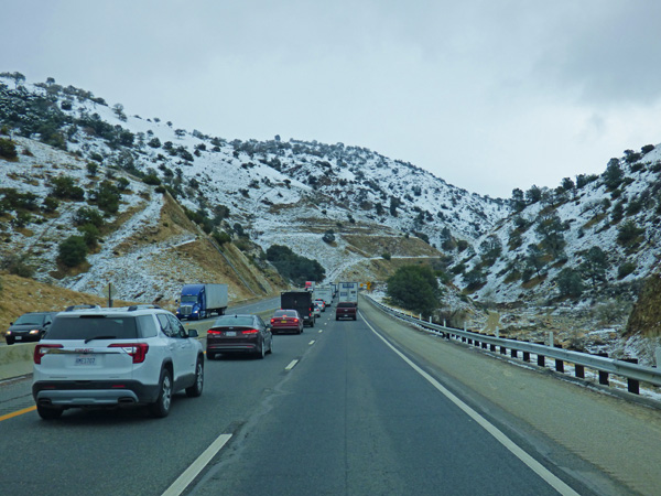
A lot of snow fell over Tehachapi Pass between Christmas and today when we went over the pass.  My guess, about a foot, perhaps more.  Yesterday the pass was open for about 4-5 hours, until it got too cold and more snow fell, and they closed it.  Today we left the Orange Grove RV Park around 9:30, and the traffic was backed up way past our highway entrance.  For about 30 minutes we traveled around 1/10th of a mile.  Then things started moving, and 15-20 minutes later we 4.5 miles down the freeway at the point where they turned people around when the pass was not open.


It took us 6 hours to travel 60 miles, and another hour to travel another 60 miles to Barstow.  WOW, what a cluster filled day!  The highway was in very good condition, it is just that with the Grapevine closed, TOO many cars and trucks...lots of trucks...traveled over highway 58 to Mojave to turn south towards the LA area.  Second, there were two construction zones which put the highway down to one lane, once for only the distance for work on a bridge, but the second one was for many hours.  Third, it would have been smart for CalTrans to have posted Tow Trucks up along the highways, because that many people means there are too many idiots who are in too much of a hurry to drive under conditions like this.  There were many times when we were stopped without moving very far for a long, long time.


Very early on I saw this CHP (pictured through my drivers outside mirror) who road the dotted middle line and slowed a huge group of cars and trucks up so that it was not a mad house going up the hill.  He did this for a good 8 miles or more, sometimes going so slow that I could not see them.  Here (pictured above) the traffic in front of us was so slow that they caught up...and eventually the CHP car pulled off the highway to turn around and do it again.


With the CHP Officer escorting the flock of cars and trucks behind us, I tried to keep lots of room between  them and those in front of us.  You can see that it started out to be a gorgeous day...but under them clouds in front of us was a heap of snow, especially in and around the town of Tehachapi (3,970 ft.), Tehachapi Pass at 3,771 ft, and Tehachapi Summit at 4,031 ft. 


The snow seemed to fall as low as 3,000 ft on the western side of the mountains, and there was snow in and around Mojave, which is around 2,700 ft.  The traffic was so thick, that many of the times the traffic stopped was under the snow line.  The longest stop we had was just beyond the point of this picture...and in an hour we moved maybe 1/10th of a mile.


Most of the traveling was slow and easy.  There were a few times that the snow made the roadway very narrow, and some idiots who did not watch how they drove, got stuck in the snow along the side of the road.  Don't know how many times people took advantage of a wide, clear shoulder to pass not one, but many many many trucks and cars when traffic was backed up or going to slow for their liking.  And those times we were backed up, many fools got out of their vehicles and stood between their cars and the barrier between the east and west bound lanes.  One guy went up to the car in front of him, and did not realize everyone was moving and he stood there talking long enough that two vehicles  behind him got into the right lane and moved past him.  If only we knew what to do about stupid drivers....


The fresh snow sure made for a scenic drive...about the only good thing about the entire drive.


Tomorrow we should get to Phoenix...