Showing posts with label Alaska Highway. Show all posts

Thursday, July 28, 2016

Finally Finished Alaska Highway – to Watson Lake, Yukon Territory

Map of 40 miles of once missed Alaska Highway

What?  I thought you have been in Alaska now for 2 months…what do you mean “Finally Finished the Alaska Highway”?   Well, back two months ago when we went to Skagway, we cut corners…going from Jakes Corner (where the “B” is on map) over to to Carcross and then on to Skagway.  Upon our return, we went from Carcross up to Whitehorse.  So technically, we missed about 40 miles of the Alaska Highway…but today, on our trip from Whitehorse to Watson Lake, we finished those 40 miles, as represented by the red travel line in the map.

Marsh Lake, Yukon Territory     Mountains east of Marsh Lake, Yukon Territory

Essentially we missed Marsh Lake, and a few scenic mountains. The road was in good condition…in fact, there was only a small area of construction which was not very bumpy.  We decided to stay at Baby Nugget RV Park just west of Watson Lake, and we lucked out by getting the closest site nearest the office…which means we have access from our site to their Internet.  Last time we were a couple of sites away, and my post did not include pictures due to the slowness of the connection.  Today the connection is good, and we have had no problems with the Internet.

Teslin River near Johnsons Crossing, Yukon Territory

Teslin Lake, Yukon Territory     Teslin Lake, Yukon Territory

The rest of our journey to the RV Park was covering “old ground”, such as crossing the Teslin River near Johnsons Crossing (top above), and driving along Teslin Lake (left and right above)…the good thing is that the construction along the lake was finished, except that they were working on the bridge near the town of Teslin, so it was one lane, 10 mph when you did go over it.  That only caused us a 5 minute delay.

Yukon Territory between Watson Lake and Teslin

Yukon Territory between Watson Lake and Teslin      Yukon Territory between Watson Lake and Teslin

There are a few things about this trip which have changed my perception about certain things…most likely I will cover these in a blog once the trip is done.  For instance, as a kid I looked upon the Yukon in the eyes of “Sergeant Preston of the Yukon”…with the Yukon being a harsh, hard land with amazing mountainous beauty.  Today it hit me just how lush and green the land is, how pure the waters are, and clean the air smells.  Harsh?  Yes, during the winter it is very harsh.  Mountains?  Yes, the mountains are wonderful.  But what was missing in the old TV show of Sergeant Preston of the Yukon was the Yukon…it was filmed in Colorado!  What a wonderful place the Yukon is…and yet we only saw a very small portion of the Yukon while traveling the Alaska Highway, along with the side trips to Skagway and to Haines.  Even if we went up to Dawson City…that is still adding a small amount of the vast area that the Yukon covers.  Like Alaska, where you only see a small portion of the state, even though you have traveled all the major highways and some of the minor highways…it is so large that you can spend a lifetime and still not see it all.   Tomorrow we start along the Cassiar Highway, down into British Columbia, on our way to see some bears in Hyder.

Friday, June 3, 2016

Skagway to Tok – Pretty, Bumpy, Amazing, Difficult

Summit Lake

You go into Skagway on a highway, and come out of Skagway on the same highway…this is a theme with many Alaska coastal towns.  Twelve miles away from Haines, but you cannot drive to Haines without going back into Canada to the Alaska Highway, get on the Alaska Highway to Haines Junction, and then down to Haines…a 20 mile coastal trip becomes a 350 mile inland trip.  So you take a ferry, or drive…and if you have a motorhome, driving is far cheaper.  But we are holding off going to Haines until later…for now, leaving Skagway, Tok is our destination…500 miles away.  We need to be in Anchorage around the 15th to refill our meds at Walgreens, then we want to be in Homer during the 4th of July after a visit to Seward.  Before Anchorage, we will probably drive down to Valdez. 

Summit Lake

Leaving Skagway we once again enjoy a visit to the Summit Lake area, where we once again find the lake in a mirror like condition.

Lone bird ruins mirror effect, Summit Lake

Except when a feathered friend lands right into the lake.  Look at what this one bird did to the reflective aspects of the lake.  Just as we are leaving, a small mist starts to fall…and a last glance to the lake shows a disturbed lake.  We are already on the highway and did not get a shot…but nearly all the reflective qualities were gone.

Cinnamon Black Bear     Cinnamon Black Bear

We saw this brown black bear, also called a cinnamon black bear, along the road.  It did not stay around very long, a bit shy, and took off into the woods.

Mountain Goat, Klondike Highway near Fraser

Between Fraser and Tagish Lake there is a pullout where you can look up on the mountainside…and way way up there are mountain goats.

Mountain Goat, Klondike Highway near Fraser

They are so far away…they are out of reach of our camera zoom…we saw at least one with a baby, and three or four more adults.  This is our first capture in a picture, and my first view of a mountain goat, Marcia saw some back in 2012 in Glacier National Park.

Tutshi Lake

Tagish Lake      Tagish Lake

The views of Tutshi and Tagish Lakes…all repeats from our drive to Skagway.  We then passed through Carcross again, and pass the Tagish Road that we came on from the Alaska Highway…now, as we stay on the Klondike Highway, we are seeing things we had not seen previously.

FAKE sheep at Caribou Crossing Trading Post

From the highway Marcia spots these two up on the rocks…conveniently right at the Caribou Crossing Trading Post…where I pull in.  I get the camera on them…and quickly realize that they are fake, a ploy by the Caribou Crossing Trading Post to bring in traffic off the highway.  We pull through the parking lot and exit…

Emerald Lake near Carcross

Next we come to Emerald Lake…you can see why it gets its name.

Emerald Lake near Carcross

The color is from light reflecting off white deposits of marl, a mixture of clay and calcium carbonate, at the bottom of shallow waters, which came into the lake from limestone gravels eroded from the nearby mountains, deposited years ago by the glaciers.

SS Klondike, Whitehorse Yukon

Soon we are in Whitehorse, Yukon, sitting in the Walmart parking lot.  We look things over, and decide we would have a better nights sleep in a RV Park and program the Pioneer RV Park into the GPS and off we go…right by the SS Klondike.  This is actually the SS Klondike II, since SS Klondike I went aground in 1936, was salvaged and used to build SS Klondike II.  The SS Klondike(s) traveled between Whitehorse and Dawson City for around 30 years running freight between the two cities along the Yukon River.  Unbeknownst to us, the GPS was running us on a bunny run…had the park on the wrong side of the Yukon River, took us down a nice dirt road for miles and had us less than 1/4 mile from the park, telling us to turn into the woods (really, no road there at all), and how it was going to get us over the river we will never know.  Of course, found a place to turn around which was just short of allowing us to turn…had to unhook the car…and the rain started to come down.  (see the rain clouds above the boat???)   Anyway, we did take the car to Walmart and then to the Canadian Super Store (think Walmart Superstore only cleaner and wider isles), and decided that Whitehorse would have to wait until our trip back through in a few months.

Saint Elias Mountains, Haines Junction

Haines Junction is the next community (population 600) along the Alaska Highway.  We filled up with enough fuel to get us to Tok, Alaska … although our intention was to stay in Destruction Bay if we liked what we saw. 

Saint Elias Mountains

We enjoyed the Saint Elias Mountains which ran along the Alaska Highway coming into, and leaving Haines Junction, and running all the way to Kluane Lake.

Kluane Lake

Our first view of Kluane Lake.  It is the largest lake in the Yukon, and the Alaska Highway runs along its southwestern border.  Two very small communities, Destruction Bay and Burwash Landing are located along this side of the lake.  Both have RV Parks, the only quality of both is that they offer electricity.  There is a nice Yukon park which offers a great view.  We choose none of the above…the air card signal was showing a weak 3G, it was 1:00, and we decided to travel on.

Kluane Lake 

But I got a great shot of the southern portion of the lake…

Parked along Kluane Lake, near Soldier's Summit

Soldier's Summit…and our dirty, soon to be much dirtier motorhome and HHR.  It was along this ridge that the completion of the Alaska Trail took place at Soldier’s Summit.  The summit is up higher than the existing road, and people do hike up to it from the parking lot on the other side of the road (see the motorhome in far distance left above).  There are many parts of the Alaska Highway which run near, but not on, the original trail.

Kluane Lake

Another look of Kluane Lake, about half way through the drive along its banks. 

Alaska Highway, Froast Heaves and closest thing to a traffic jam

This is where the “Difficult” comes into play.  From Destruction Bay to Beaver Creek Yukon, just short of the Alaska border, is the most difficult, frustrating, hard part of the entire drive.  You face many many frost heaves, (the uplift of water-saturated soil or other surface deposits due to expansion on freezing), and then 50 miles of road construction, some of which is very, very difficult to deal with.   As before, you get Construction Warning Signs, the a couple of miles later, the asphalt disappears and you are running on what feels like a washboard…

Washboard to clean clothing     Roadway Washboard

On the left you see a washboard…on the right, you see a “roadway washboard”.   The road was like the picture on the right that we drove on for miles and miles and miles.

Road Construction Equipment causing Washboard effect

It was something similar to this that was the culprit.  It was so hard to drive on, and Marcia was in no mood to take pictures or even look at the roadway, that we did not get a picture of the real machine, but got a picture of a better stretch of gravel (picture below).   Now there were stretches of this type of road, and it was the first long stretch which was the worst.  At times, I could only drive 12-15 mph, and even then the shaking was earth shattering.  Then large trucks would come shooting by the other way, at about 40 mph.  Many cars passed us, along with some motorhomes. 

Alaska Highway Road Construction, between Destruction Bay and Beaver Creek

Then we ran into the construction which required us to follow a pilot car, then it turned into normal road for a couple of miles, then back to gravel…but the washboard syndrome was gone.  They had put a layer of dirt over it, which filled in the gaps, and lesson the shaking, and increased our speed to 30-35 mph with only short spurts of slower speeds. Finally it was over, finally we were at the border.  After being cleared through, I asked the agent if I could ask him a question.  “Sure,” he said.  “Are the roads better here in Alaska?”   He looked at us, smiled, and said, “Better than what you just traveled through…but not as good as the lower 48.”   Well, after arriving at Tok, I have to say that he was wrong…the roads are better than many roads in the lower 48, as long as you slow down for the dips and sways. 

Canada Alaska Border Flags     Alaska Border Sign

FINALLY, we are there!  We have gotten through the worse part, and when we return, we hope they will have much of the road construction finished…after all, they have two full months, and 20 hours of daylight each day.  Smile

Alaska Range over Midway Lake, east of Tok, Alaska

Looking to the south at the Alaska Mountain Range over Midway Lake.  We arrive in Tok around 7 pm, Alaska Time.  Yes, it took us 7 hours to travel 225 miles.  (Yes, 1 pm to 7 pm is only 6 hours, but we changed time zones.)  We are staying in Tok for two nights to rest up, clean up, and east at the famous Fast Eddies Restaurant.  (We had breakfast there today, and intend to return for dinner tonight.)

Sunday, May 29, 2016

Fort Nelson B.C. to Tagish Yukon


Wildlife

Stone Sheep, Alaska Highway

Just driving along and there they were, two Stone Sheep standing alongside the road shortly after we left the Muncho Lake area.  They are a different spieces than the Big Horn Sheep that we have seen in the past, and are found in northwest British Columbia and southwest Yukon.

Black Bear, Alaska Highway

Had a question via email about just how far away are we from the bears we see.  The answer is, it varies.  Along the Alaska Highway, there are many stretches were the trees and underbrush is cut away from the road by 20 yards on each side.  All of our bear sighting along the highway look like this to the left.  Marcia caught herself on camera along with the bear.


Black Bear, Alaska Highway

Between the zoom on the camera, and enlarging using Photoshop, the bears can look very close.  Above is the same bear as the previous one…we are both sitting in the motorhome still, safe and sound (as we have with all bear pictures, unless we are safe and sound in the car of course).

Black Bear, Alaska Highway

This is one that Marcia took later in the day.  This bear walked along the tree line for about a tenth of a mile before it cut into the woods.  The zoom makes it look like we are right near it.  The third bear I saw too late.  One thing about towing a car with all four wheels down is that you cannot backup…not even a few feet because it can bind and break the tow bar.  Now we are not going very fast…what cars we do come upon are from our behind, and they race on by as soon as they can find a place to pass, which is not very long considering that many just pass even if they have solid double lines.  I think we passed one small van yesterday, otherwise everyone has passed us by.  We are enjoying this long drive the most we can.  Anyway, going about 48 mph in a 62 mph zone (62 mph = 90 kph) and I look off the left of the road and see the head of a bear in the culvert just off the roadway.  This would have been the closest we had been to a bear while on the Alaska Highway…but by the time I stopped we would be too far away, or if I stopped too fast then everything we own would be sitting in the front seat with…so I just kept going.
Black Bear, Alaska Highway

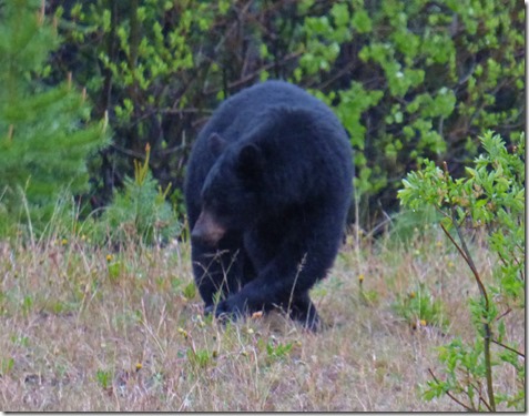
Today we were driving along and saw that a car going the other way had stopped…so I slowed way down and sure enough, this black bear was on my side of the road over by the trees.  I must have taken a half dozen shots or more, and put the camera away and just started to give it gas…looked in my mirror and glanced over at the bear again AND…

Black Bears, Alaska Highway

It was not alone!!!  A brown bear was there too…and by the time I got the camera again and focused in and shot, the black bear was shooing the smaller brown bear away…you can see him showing the brown bear his teeth.  A swat with his left front leg and the brown bear disappeared before I could get another shot of it.  We stuck around for another 30 seconds and the black bear was headed for the cover of the trees too…so we drove on.

Buffalo, Alaska Highway     Buffalo, Alaska Highway

Saw Buffalo a few times, never in large numbers as you do in Yellowstone.

Moose, Alaska HighwayThis one is hard, I know…but we had just gone over a bridge and around a corner in a snow/rain fall, and there she was, our first Moose.  Marcia had the camera in her hands having just taken pictures of the river the best she could, but she could not get the camera to focus on anything other than the drops on the windshield.  I have had this happen to me before, and sometimes you just have to turn it off and back on.  But Moose are shy.  Even though I kept my distance, she looked at us, and ran off into the trees.


Yesterday’s Scenery

Bubba in Snow, Alaska Highway

It did not take long before we hit some snow yesterday, and the wildlife that travels with us needed to take care of business.  Normally we take care of business before we leave…but the trees put sap on the ground, which got into their paw pads, and then everything starts sticking to this gooey mess.  Besides, a little snow is good for us…but never fun to drive in.  Nothing stuck to the roadway, thank goodness.


Alaska Highway Views      Alaska Highway Views

Eventually the surrounding mountains started to show.  This was around the Stone Mountain / Toad River area.

Alaska Highway Views

We then enter Muncho Lake Provincial Park, and I so much wanted a break in the clouds…

Alaska Highway Views   Alaska Highway Views

…but the cloud cover is ruthless…enough to let us know we are in a pretty spectacular place, but not enough to let us fully enjoy it in its entirety.

Muncho Lake, Alaska Highway

Even so, Muncho Lake is a beautiful place…that turquoise colored water with the cloud draped mountains surrounding her.  For those who can put up without having anything…no Internet, no electricity, just solitude and beauty, there are some amazing RV sites where you can put your nose right up to the water and just enjoy.  Not for us today, we push on…it is still early, just hitting 10 am when we arrive.  But we stick around for awhile to enjoy, and to rest up for the rest of the days journey.

Muncho Lake, Alaska Highway

One last look back at Muncho Lake, from the pullout on the north side of the lake.

Alaska Highway Views

Although the lake is behind us, the Muncho Lake Provincial Park continues on.  The lake is in the middle of the nearly 60 miles that the Alaska Highway goes through the park. 

Alaska Highway Views

Now the Trout River hugs the side of the roadway, replacing the Toad River which hugging the road as we entered the park.

Liard River, Alaska Highway

The Trout River empties into the mighty Liard River, which will flow for hundreds and hundreds of miles before it reached Fort Simpson and empties into the Mackenzie River, which is the largest river in Canada, and exceeded only by the Mississippi in North America, and finally empties into the Arctic Ocean far to the north.   Above we are crossing the Liard River, which will now run on my side of the road.

Liard River, Alaska Highway   Alaska Highway Views

Except for when we run across an old Forest Fire, everything is a luscious green.  It did not take long after we passed this mountain on the right before we had one of our bear sightings yesterday.

Yukon Sign, Alaska Highway
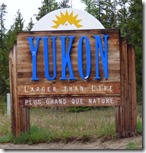
Finally we have reached the Yukon…kind of.  After entering Canada from Idaho back on May 15th into British Columbia, we have spent all of our time in either B.C. or in Alberta.  Most of our travels have been in B.C. until yesterday when we finally, after 555 miles on the Alaska Highway, we enter the Yukon.  But just a mile later we are back in B.C., and less than 2 miles later we are back in the Yukon. Yukon Sign, Alaska Highway For some 50 miles we cross back and forth, finally crossing for good for the day and we head for Watson Lake…just to awake today, start driving and re-enter B.C. again on last time before entering back into the Yukon.  It is that entrance before Watson Lake that we see an official sing welcoming up to the Yukon.  Unlike Alberta and British Columbia, the Yukon is not a Province, it is a Federal Territory.  The major difference between a Canadian province and a territory is that provinces receive their power and authority from the Constitution Act, 1867, whereas territorial governments have powers delegated to them by the federal government.   That’s your history lesson for the day.

Tourist Landmark

Sign Post Forest, Watson Lake, Alaska Highway

Let me take a break from the scenic and tell you about Sign Post Forest in Watson Lake.  It was started by a homesick GI back in 1942 when the Alaska Pioneer Road was being built.  The story of how started is this:
In February 1943, Private Carl K. Lindley, of company "D", was sent to the Liard River area to build a sawmill to cut trees for logs needed to repair bridges. Then the squad moved to the border of the Yukon and BC, near Lower Post. One day they were building a loading platform for gravel trucks. There was an accident and Lindley's feet were run over by a truck. He was taken to a regimental aid station at the intersection of the new Alaska Highway and the existing road leading to the Watson Lake airport.

Though not badly hurt, he couldn’t walk very well and was unable to work on heavy construction. So his company commander put him to work painting roadside signs and regimental numbers on various pieces of equipment. One day in February 1943, Carl was ordered to repaint a sign on the road which had been damaged by a bulldozer.

When he finished that little job, he decided to paint the name of his hometown on a board and nail it to the same post. Carl Lindley painted the words "Danville, Illinois, 2835 miles" Thus began the tradition of painting place names along the Alaska Highway which continues to this day as the world- famous Watson Lake signpost forest.

In August of 1943, Carl Lindley, and other members of his company D of the US Corp. of Engineers, was a sent back to the United States for further infantry training. Then they sailed to England in October 1943 and took part in the invasion of Normandy on D-Day in 1944, and the infamous Battle of the Bulge.

Carl Lindley passed away in 2002 at the age of 83. But his role in the history of the Alaska Highway is forever etched in that single board attached to a makeshift pole at Mile 635 of the Alcan Road in February 1943.

Now, license plates are the number one “sign”, followed by road signs and homemade signs.  However, there are other type of signs too…and I added a unique little sign of our own.  Back in September 2014 we visited the Little A'Le'Inn, in Rachel, Nevada.   Arkansas UFO License, now part of Sign Post Forest, Alaska HighwayMy brother Roger and his wife Rochelle do sideline work there…Rochelle more than Roger since he has a full time job in Sacramento.  While visiting, Roger gave me an official Area 51 Arkansas U.F.O. License.  Marcia got a Florida one…but hers slipped into the confines of a dark hole inside the RV and we have not been able to retrieve it.


Arkansas UFO License, now part of Sign Post Forest, Alaska Highway

Now the Area 51 Arkansas U.F.O. License sits as a part of this monument in Watson Lake…I am sure there is nothing like it there.

Sign Post Forest, Alaska Highway     Sign Post Forest, Alaska Highway

Sign Post Forest takes up a couple of acres…I couldn’t begin to show the vast amount of signs that are here.  Thank you Private Lindley for your service to our country.   On this Memorial Day weekend, we must all remember this saying, “All gave some and some gave all…”


Today’s Scenery

I know this post is getting long…so is the drive along the Alaska Highway.  Smile  

Alaska Highway Views

We both went to bed early, and everyone, us and the dogs, had a good nights sleep.  But again, with the sun still up when we went to bed, and up when we awoke, we decided to leave shortly after 6 am.  The sky was overcast again, as we passed over the Little Rancheria River, which runs into the Rancheria River which we travel next to for many miles.

Alaska Highway Views

There are many lakes and the river along the route…wish it also brought blue skies.

Alaska Highway Views

Civilization is rarely seen along the highway.  Down in the states you have troubles finding stretches of highway that don’t have any services within 50-60 miles away…here it is the norm.

Alaska Highway Views

Although we saw snow on the mountains, we did not face any snow today.

Alaska Highway Views     Alaska Highway Views

Alaska Highway Views

And then the clouds started to dissipate…and we saw blue Yukon skies for the first time…or were we back in the B.C.?   Who cares, it is blue sky!

Alaska Highway Views

Even the sun tries to pop out!

Alaska Highway Views

Before long we are coming into Teslin, part of the Nisutlin River Delta. 

Alaska Highway Views

I was impressed with the information displays they had at this pullout overlooking the area.  This is just a small portion of one which shows the journey of the Chinook Salmon from when they enter the Yukon until they reach Teslin.

Alaska Highway Views

At the top of Teslin Lake we cross the Teslin River near Johnsons Crossing.  Tesline Lake is about 70 miles long, and we only have about 40 miles left to get to today's destination, Tagish.  Shortly after passing through Johnsons Crossing, we turn off the Alaska Highway and head to Tagish…which is 90 miles from Skagway.  We will meet up with the Alaska Highway again in Whitehorse after we leave Skagway in a few days.


Road Conditions
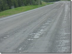
Alaska Highway ViewsOverall, the Alaska Highway has been a fairly well maintained road.  However, there are stretches which are bad.  The occasional frost heaves areas are not bad, and well marked…you slow down, avoid or go over them, and that’s it.  But when they decide to fix stretches of roads, they take off the layer of Asphalt, then run a grader over it, then you just drive on it.  They seem to do miles at a time…and it is hard to drive on, rattles the heck out of you, and you wonder how long it will go.  Case in point…yesterday we see a sign, “Construction Zone”, and then a sign, “Work being done by Cobalt Construction”.  We drive on, see no workers, and the road looks like this above.

Alaska Highway Views

Then we finally see this guy on this scraper, chewing up the road.  I tell Marcia, “I think we just found Mr. Cobalt…it looks like it is a one man company.”  And the road continues, all torn up, all bumpy and shaky.


Alaska Highway Views
Finally we come to an area where the rest of the Cobalt Construction is working, and now they have a pilot car which has to take you along.  The escorted drive is a few miles, and it is hard and bumpy…and I am not driving as fast as the leader.

Today we had numerous stretches along Lake Teslin where the road was totally chewed up, down to gravel, and we never saw any work being done, no signs of equipment, just signs warning you to slow down, it is dusty, and you never knew how long it would last.  Now that is something we have never experienced before…although stretches of Highway 99 in California have been almost this bumpy.  Smile