Showing posts with label Snake River. Show all posts

Sunday, September 27, 2020

Juniper Campground, near Ririe Idaho along the Ririe Reservoir


We had 200 miles travel from Busters to Juniper Campground near Ririe Idaho, which is just east of Idaho Falls.  Very quickly we started seeing farmland.

The clouds came and went throughout the day, and even dropped a few raindrops here and there.  The wind from the west sure helped provide good gas mileage.

Lots and lots of hay has been harvested lately.  On many farms you can see where they have the hay all locked down and under cover.  Saw a few semi trucks loaded up with Hay traveling west.  And some fields, like the one above, which still needs to gather up the hay bales and get ready for winter.

 
Crossed over the Snake River many times today.  The first was in a deep canyon as we exited Twin Falls.  This one was along I-86 and as you can see, it was very wide.  One of these days we need to spend a lot of time just photographing the Snake River...

Here the Interstate heads right into that mountain and eats you up!  Well, it looks that way, but it really veers off to the left.

Lots of interesting Rock formations as you approach Pocatello.  I think this was part of or near Massacre Rocks State Park, a famous spot along the Oregon and California Trails.  Also known as "Gate of Death", or "Devil's Gate".  The emigrants gave this name to the narrow passage of the trail through the rocks, from the fear of possible ambush by Indians.


This picture I needed help from my brother-in-law Arny, who grew up in this part of Idaho.  This is the Don Plant, constructed in 1944, and was the first fertilizer production facility built by the J.R.. Simplot Company, which still operates it.  That large mound, hill, nearly a mountain behind it is all fertilizer.  To us it looked like coal, but when I talked to Arny he let me know what it really was.  Thank goodness the wind was blowing from the west...did not smell a thing.

Although it was only a 200 mile drive, we didn't get to Juniper Campground until after 2.  Check in is at 4...but we saw no one to direct us, no one has asked for paper work, have not seen anyone other than other campers.  There are three sections to the park.  Section A requires reservations, which I made for one night last night.  Section B and C are first come, first serve sites.  I thought we could probably drive up and snag one of those sites, but it was a Saturday, and I wanted to be sure. 

We have now decided to stay for another night or two because a cold front is coming into the area of the Tetons and I wanted to boondock at least one night there as we pass through.  Tomorrow night it is predicted to be in the low 20's, upper 20's for Monday, and back in 30's Tuesday with a high of 70 instead of mid-50's Sunday and Monday. 


I think Indy is all for staying here, after all, this backyard is so much larger than Sandy and Arnys...but it is shared, and she has to wear a leash....none of which pleases her much.  But anything is better than another day of travel.

And there are a lot of worse spots to stay at for a few days, that is for sure.


Ririe Reservoir was created in the early '70s to assist with irrigation and flood control.  It was built on Willow Creek, but Deer Creek, Blacktail Creek and Meadow Creek also feed into the reservoir, and eventually it all feeds into the Snake River.  As you can see in the map above, the lake is very narrow, very long, and very curvy.  It holds 124,000 megaliters, and has a surface area of nearly 4 square miles.  (A megaliter is equal to 264172 gallons).  The reservoir contains six species of fish, rainbow trout, kokanee salmon, cutthroat trout, smallmouth bass, and yellow perch.


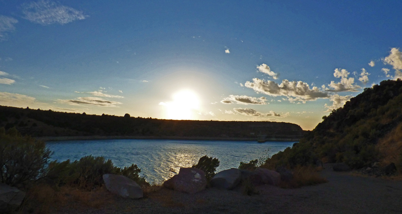
As you can see, it is a very photogenic lake, with it narrow sides, along with rocks, rolling hills, and glistening water.


Thursday, May 5, 2016

Utah to Wyoming to Utah to Wyoming to Idaho to…

Map of route from Jordanelle Lake to Victor Idaho

The route from Lake Jordanelle State Park to Victor Idaho, which is only 19 miles west of Moose-Wilson Road, which leads to the Granite Canyon Entrance of Teton National Park.  Victor has a Passport America RV Park, where we are staying.  More about the park in a couple of days.  As for our Route to Victor, it really does go from Utah to Wyoming to Utah to Wyoming to Idaho to Wyoming and back to Idaho again.  That’s six state lines in 270 miles.  For those who travel from state to state, you probably know by now that cell phone service seems to die along state lines sometimes.  Today was no exception, and we needed to call the park to make reservations to get the Passport price which essentially is two nights for the price of one.  Considering RV parks in and around Jackson and Jackson Hole are going for $75 to $95 per night…and the National Park campgrounds don’t have electricity to keep you warm when it gets down to 35 degrees at night…being in Victor was the best option.  Also, we won’t have any back tracking since we will just head north out of Victor into Montana when we leave.

Echo Lake     Echo Lake
I-80 near Wahsatch, UT

The first part of he drive up I-80 to Evanston is one which I am very familiar with.  Past Echo Lake, and some red rocks along a canyon from which the Interstate runs.’'

Near Almy Wyoming    North of Cokeville, Wyoming
North of Cokeville, Wyoming

In Evanston we turn north off the Interstate, and pass green fields, rock formations and lots and lots of pasture land full of cattle, horses, sheep and even llamas.

Salt River Pass    Salt River Pass
Salt River Pass

The Salt River Pass, at 7,630 feet, was the most difficult climb of the day, but the views were well worth the slow climb.  Traffic was light, so I did not have to pull over very often.

Afton Wyoming

The largest town between Evanston and Victor is Afton Wyoming.  It is just a little smaller than Victor, but looks a little more interesting…but we have hardly seen any of Victor yet.

North of Afton, Wyoming

Much of today's drive included views of snow capped mountains.

Near Alpine Wyoming

Palisades Reservoir was the largest body of water that we saw.  The Snake River runs into the lake, along with various creeks, and contains over 1 million acre feet of water.  The Snake River Range has 10 mountains over 9,000 feet, and boarders the lake, and the river “snakes around” to the east side of the mountain range.


Palisades Reservoir

It was a very interesting drive today.  Read various information boards about some of the towns and passes.  Almy Wyoming was an early coal mining town, but they had too many explosions and shut down the coal business in the early 1900’s.   Cokeville Wyoming was originally a fur trapping and trading area, and was a well traveled pathway along the Oregon Trail.  The Mormon Church created he first settlement in the area in 1874, and the Oregon Short Line Railroad went through in 1881.  By 1908 Cokeville consisted of 2 saloons, a hotel, a store and boarding houses, and continued to grow.  In 1922 it made national headlines when Ethel Stoner became Mayor and two other females won seats on the town council.  The ran on a law enforcement ticket, wanting full Prohibition laws instituted...but the local police refused to enforce the Prohibition laws.  Near Salt River Pass, the Lander Cut-off of the Oregon Trail headed north along our route for awhile, by-passing Fort Bridger near the Wyoming and Utah borders, cutting off many miles for those traveling to Oregon.

West side of Tetons, near Victor Idaho

So Victor is on the West side of the Tetons.  It is the largest city in Teton County, and is seeing growth from those who cannot afford to live in Jackson Wyoming to the east over the 8,400 foot Teton Pass, about 2,000 feet higher in elevation than Victor.  Back in 2012 when we were visiting Yellowstone, we stayed at Henrys Lake, which is only 85 miles to our north, also on the eastern side of the mountains, and only 15 miles west of West Yellowstone.