Showing posts with label Folsom Lake. Show all posts

Thursday, May 24, 2018

Yes, Back in Citrus Heights—Folsom Lake is FULL!

At sister’s hours in Citrus Heights, CA

Folsom Lake from Granite Bay State Park

Folsom Lake, above, from Granite Bay…which is where, in my day, everyone went for Senior Cut Day.  When I was in High School, I only had ONE unexcused absence.  That was for Senior Cut Day, but not for ‘my’ school, for a neighboring school where I kinda of had a thing for one of their cheerleaders.  For ‘my own’ school’s senior cut day, I did not go to school, I had to work instead.  But the school always gave everyone a pass for senior cut day, “IF” it was senior cut day for that school…not a neighboring school.  $12 gets you in at the State Parks around Folsom Lake…but I explained to the nice young lady that all we wanted to do was get a few pictures, and she gave us 15 minutes to do so…so we did.

View from Rainbow Bridge, over American River, Folsom CA

After being back home at my sister’s for 1 1/2 days, getting setup, doing laundry yesterday along with shopping and getting the car washed, today we went by to visit mom and dad.  Afterwards, we drove to Folsom, the town, and then on to Folsom Lake.  This is the picture when one crossed Rainbow Bridge over the American River in Folsom, a bridge that is around a hundred years old.  The bridge in the picture is only twenty or thirty years old…but I love Rainbow Bridge, swam down in that water a number of times, fresh water coming right out of Folsom Lake.

Johnny Cash Trail, near Folsom Prison, Folsom CA

Last year the City of Folsom opened phase one of the Johnny Cash Trail, a 1.2-mile segment of Class I bike trail that connects the Folsom Lake Trail by way of a new bike/pedestrian over-crossing, beautifully inspired by the architecture of nearby Folsom Prison.  Eventually they will have large art works displaying the life of Johnny Cash and his connection to the nearby Folsom Prison, along with a 3 acre park…a nice tribute to the man who made Folsom famous. 
Folsom Dam

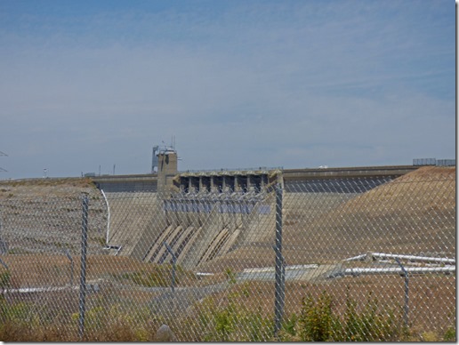
Marcia got a nice picture of the newly improved Folsom Dam, which just last year was completed and added some 15 feet to the height of the dam.  When I was young we use to drive across the dam, and every school kid took a tour inside the dam…oh, how times have changed.

Folsom Lake from Granite Bay State Park     Folsom Lake from Granite Bay State Park 

Give it another few weeks and these beaches along Granite Bay will be packed each and every day.  The lake is full with a height of 464 feet, and nearly 954 thousand acre feet of water behind the dam.  Capacity is 977,000 acre feet.  Just a month ago, the lake was only 58% full, and dropping.  They have to have room for the spring runoff from the Sierra Nevada mountains, and in May, the runoff was real good.  It was only a few years ago that the lake was half full at the beginning of June…yes, the drought is over in Northern California.

Folsom Lake from Granite Bay State Park

The lake is very popular for swimming, fishing, and for boating.  today there were just a few boats out there…

Folsom Lake from Granite Bay State Park

…just imagine how many will be out there Saturday, Sunday and Monday.  However, the weather is really playing games around here.  High in the upper 70’s today, but only low 60’s tomorrow (Friday), just to bounce back to low 70’s Saturday, mid-80’s Sunday, and low 90’s on Monday.  Up in the mountains it will be at FREEZING during the night…welcome to the opening of Summer!

Folsom Lake from Granite Bay State Park

We thought about driving all around the lake, but after getting into Granite Bay, figured I had enough memories to deal with.  They use to let you drive right out to the shoreline…not anymore.  I have had many a sunburn in my life, a few of the worse ones right here at Granite Bay.  Do you know how hard it is to cook in a restaurant’s hot kitchen with a bad sunburn???  I do, it is very, very tough.

Sister Sandy and Sister Patti (no, not nuns) are headed up to Reno tonight for a three night vacation away from work and work.  Arny’s mom will still need to be taken care of, and I willingly offered my assistance to help Arny take care of his mother Euleda. 

Tuesday, April 12, 2016

Skruffy Dog in the Clouds, Placerville Trip

Skruffy in Clouds

Yesterday I was sitting down resting after dumping our tanks.  While at my sister’s house, we use a blue tote to empty them, which is not an easy task sometimes.  As I was looking up in the sky, I see this cloud which starts to look a bit like a dog. As I look at it more and more, I realize that it looks more and more like Skruffy running.  You see, she “hops” when she runs.  

 
Skruffy running


Looking through some of the hundreds of pictures I have of Skruffy, this one to the right came closest to hat I was talking about.  Over the years her hair has been much longer than it is now…which is one of the reason she was called Skruffy when I rescued her.

Mom wanted to travel up to Placerville the other day to have lunch at the Buttercup Pantry.  We have been up there a few times, but this time I brought my camera to get some pictures of it.  On the way up there, I decided to drive by Folsom Lake to see how high the lake really is.

Folsom Dam

Here is the dam above, and lake below. 

Folsom Lake

This is the highest I have seen Folsom Lake in a few decades now.  Not that it has not been this high for 20+ years, but it has not been this high the past four years that we have been coming to California during our travels. It is nearly 80% full, and they need to have room for the rest of the spring snow runoff coming out of the Sierras.

Buttercup Pantry in Placerville     Buttercup Pantry in Placerville

The Buttercup Pantry restaurant is right in the downtown area, has a small parking lot, but is well worth any parking problems to eat there.

Buttercup Pantry in Placerville

Despite the sign, they let me use the front door….

Buttercup Pantry in Placerville

This is some entryway in picture above…

Buttercup Pantry in Placerville   Buttercup Pantry in Placerville 

Buttercup Pantry in Placerville

The inside of the Buttercup is very interesting.  The food was good, and it was a nice drive up and back.  Since we are only going to be around for about a month, we told mom that we would try and go somewhere every week … the smile on her face told me that she was very agreeable to that!

18 days till departure...

Tuesday, November 10, 2015

Rain Rain don’t go away

Disclaimer:  I did not take any of these pictures, credit can be found by putting mouse over each picture/image.

KXTV Picture of Mammoth

Two snows and rains within eight days of each other offers hope to Northern Californians who have been suffering through a number of years of drought.

Boreal Mountain, Ca. November 2, 2015, abc10.com     Near Donner Summit, abc10.com

Of course, to make a real impact on the drought, they will need somewhere around 30 feet of snow up in the Sierras.  Here are some of the historic figures for the Sierras along highway 50 and I-80:
  • 1 day snowfall: 67 inches (5.6 ft.) at Echo Summit, Jan 4, 1982 (2nd in US)
  • Single storm snowfall: 186.6 inches (15.6 ft.) at Donner Summit, 1982 (2nd in US)
  • 1 month snowfall: 390 inches (32.5 ft.) at Tamarack, Jan. 1991 (US record)
  • Total winter snowfall: 884 inches (73.7 ft.) Tamarack, 1906-07
  • Greatest snow depth: 451 inches (37.6 ft.) at Tamarack, Mar. 11, 1911 (US record)
  • Highest average March snow depth: 108 inches (9 ft.) at Echo Summit
So “historic” snowfall would do much to relieve the drought…but what is really needed is a few years of near historic, along with finishing the maintenance work on Folsom Dam which is preventing it from being filled to capacity “if” there was enough rain to do so.

Tornado Warning, KCRA

Not only did we have rain and wind today down in the valley, but south of Sacramento there was even a Tornado Warning, although no report of a tornado hitting the ground or any damage.

Storm - KCRA

Seeing pictures like the one above reminds me of the many years spent in Arkansas!

Folsom Lake, KCRA     Lake Oroville, KCRA

Above are recent pictures of Folsom Lake (left) and Lake Oroville (right), both at or near record lows.  Water should be covering most of the dirt areas behind the dam on the left, and in the entire picture on the right. Oroville feeds the Sacramento River (as does Shasta Lake much further north), and Folsom feeds the American River which merges with the Sacramento River in Sacramento.  River levels are not as low because they need to be at levels compatible for the Salmon, Shad, Striper and Sturgeon runs (although technically I don’t think the Sturgeon don’t have runs).

Folsom Lake Flood Stage -- watereducation.org

Above is a picture of Folsom Dam with all gates open, and the lake at flood stage. 

Tower Bridge a flood stage, Sacarmento -- sacratomatovillepost.com

Above is a picture of the Tower Bridge, which spans the Sacramento River between Sacramento and West Sacramento…you can see it in the the TV show “The Mentalist” in many episodes.

Most of Sacramento is in a flood zone…much like New Orleans. The American and Sacramento rivers meet in Sacramento near downtown. Earthen Levees surround the city along these rivers.  Sacramento has the second-highest flood risk of any major U.S. urban area. If a levee breaks, some residents could have as little as 20 minutes to flee.  During times of drought, and frankly during most years, this is not a thought to most of the people who live here…until there “one of those winters”…a winter in which the dams are near capacity or are being kept low to handle the high snow pack in the mountains. 

Yolo Bypass -- wikipedia.org

When I lived in Sacramento for 31 years, I saw the river levees just feet from overflowing.  Two of these times I lived just a city block or two away from the levee.  At times like that, you also worry about levee breaks, something that has not happened in Sacramento for many many years now…but it has happened further up north in places like Yuba City, or further down the river in the Delta. So far Sacramento has been saved due in part to the Yolo Bypass (above) which floods the west side of the river as the river reaches certain heights.

inkcinct.com.au

So we know that the lakes will once again fill, the rivers will continue to flow, and one of these days they will be talking about flooding again.  That is the way of life in Sacramento. Thank goodness that while Sacramento is at a mere 13 feet in elevation, Citrus Heights is at 167 feet…so mom and dad and sisters are all safe…but other family live in the lower ground, so we always worry when the water starts reaching the top of the levees.  But for now…”rain rain don’t go away, we need the water for future days.”