
The Sun comes up early in Arizona, because Arizona does not do Daylight Savings Time. So 5:00 am is really 5:00 am, and the sun starts coming up at 5:00. By 6:15 the sun was coming through the window covers...and we started to get up. By 7 am, we were on the Interstate, headed for Needles California, about 260 miles away. The picture above is of the San Francisco Peaks, by Flagstaff. The highest peak, Humphreys Peak, is the highest point in Arizona at 12,633.

It was shortly after this picture was taken, as we were driving west following the GPS and listening to a Country Western Radio Station that I suddenly heard some static in the music, and just as I said, "Uh Oh...." ZAP, the GPS (and all that comes with it) goes ZAP again. Well, I guess it isn't the CD Player after all...it must be a speaker wire (based off of the static) -OR- the entire GPS is just past its prime and needs to be replaced.

I knew there was a Cracker Barrel along the Interstate in Flagstaff. The picture above is from Google Maps Street View from the Interstate...and it almost looks like what we faced today. I figured that if we could find a parking place, I would order breakfast ToGo and get the GPS running, grab our breakfast, eat and be on our way. And it all worked out, despite the dozen or so RVs in and around the lot...most looked like they stayed there all night.
We barely made it out of Flagstaff, where there is much construction and very bumpy roads, and ZAP, the GPS bit the dust again...this time with nothing else going but the GPS.
TAPS for the GPS
Gone the sun,
No more lake,
No more hill,
No more sky.
All is well,
Safely rest,
God is nigh.
Marcia got this picture facing north...nothing of interest up there except for a fairly large trench known as the Grand Canyon.


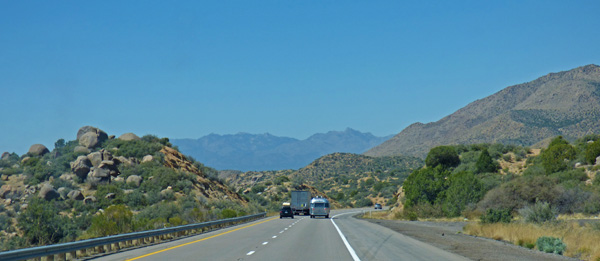
This is the exit we take on our way home each fall/winter, except we are going the other way. We like US 93 through Wickenburg, and yes, that silver trailer is right in front of us...but we lost them shortly after when Indy needed to take one of her breaks and we pulled into a TA Truckstop. (Ok, the stop was for me, and I also needed to call the RV Park in Needles.)

Here we have just passed through Kingman. The exit sign is for Las Vegas, and as soon as we went around that corner there was a huge backup in the right lane. I took the chance and got in the left lane, zipped by everyone who were simply getting off at the Las Vegas exit and causing a backup on the Interstate.

Had to toss in this picture of the Pilot sign. Yes, unleaded for $4.39...and there is a Love's which has the same price. Both stations were very busy with this exit just 9 miles from the California boarder. I got as much in the tank as I could possibly put in!

And there is the boarder just one mile ahead, you cross over the Colorado River and you have crossed over into ...

We arrive just past 2 pm, and enjoyed the shade as we could. It got up to 87 degrees, 9% humidity, and just about the upper level of our comfort zone. Now it is 9 pm, it is 80 degrees and it feels just fine. It will get down to 62 degrees by the time the sun comes up.
We are again at Fender's RV Park, a Passport America Park where we pay $19+ (I just gave her a twenty and told her to keep the change) and we are in the exact same campsite we have been in the last 3 or 4 times we have stayed here. Indy has been here before, last November on our way home. She 'seemed' to smell more here than other places, she may realize that she has been here before. If so, she must know that the big green lawn in Citrus Heights is awaiting her, along with her aunt and uncle who we 'HOPE' she will be nice to immediately. Now, all I have to do is try and remember my way back home to Citrus Heights where I called home for most of 1975 through 1983.