Tuesday, May 22, 2012

Burney Falls

Today we headed north 22 miles to visit Burney Falls at McArthur-Burney Falls Memorial State Park.  We decided to not pack a lunch and to hope to find a place to eat at if we could find one. But first, we had to find some 3G to post yesterday's activity because for some reason, the Internet here at the RV Park locked both Marcia and I out for "going over the usage rates".  This surprised me, especially with Marcia because she had hardly been on it when it locked her out.  I had posted the KOA posting and nearly had the Lassen posting done when I got locked out, and I figured all those pictures had used up my limit.  As of now, I am not locked, so there was an error with their system.

We headed to the town of Burney, and I found a great 3G connection and took care of business.  Well....the full truth is that the GPS took us to Burney instead of Burney Falls, but while in Burney, I took advantage of posting the Lassen travel blog....and figured out the right way to Burney Falls.

Burney Creek and underground springs form Burney Falls, and is all named after a pioneer settler Samuel Burney.  The falls is around 130 feet tall, and has a constant flow of around 100 million gallons of water each day.  It is a very nice looking water fall, and it was easy for Marcia to get to the viewing point to see it as it was a asphalt path.  Now we could have tried to go to the bottom where we could look up at the falls, but we both felt that the scooter would just not handle that climb back up, so we settled for the view we had above.  Here are the pictures...
Initial view...somehow I need to get Marcia down those stairs to where that lady is standing....I go down the stairs and find a path far off to the right that she can ride down with the scooter....thank goodness for that.
This is their information placard talking about the falls.  Below are just a few pictures from the observation area....


And a close up of the area between the two main falls....
Just remember, if the world feels like it is closing in on all sides, like everything is rushing by and you don't have control....keep your feet planted in solid ground and all will be well....your troubles will rush by you, and you have the prime viewing seat to watch it flow by.

To end, here are a few more pictures of the RV Park we are at.  Tomorrow will be another short travel day of 70 miles to the other side of Lassen.


Lassen National Park

Today we left the KOA and headed to Rancheria RV Park which is located on Highway 89 between Lassen National Park and Burney Falls.  It was a short, 45 minute drive.  This RV park is a typical "sites close together" park, but very quiet with a bunch of friendly people who are here as a group of around 10-12 RV couples from the Paradise California area.  Below is a picture of them all grouped together.
Shortly aftere we arrived at the RV park, we packed up a lunch and the dogs and went to Lassen National Park, which was 22 miles away.  Once we got there, we found out that we would have limited access to the park because they are still getting the snow off the highway in the high country (hey, the snow only accumulates to around 40 feet along the road in the high pass area, what's taken them so long...lol), and they go into summer mode in June, not May.  However, we still were able to get to a good area to view the volcano and the massive damage which took place when it last erupted.
Unfortunately, the weather was not the best to capture this mountain....there was a bit of cloud cover, which makes it hard to take a picture which shows the mountain as it would be against a clear, blue sky.  There is still a lot of snow on the mountain, and the snow can stay throughout the year on the north side of the mountain, which you can see here.
The picture above is from what they call, Area of Destruction.   Lassen blew up and out towards the camera, which is 3 miles from the center of the volcano.  Nearly all the trees from this point and up to the mountain are younger trees since the blast took out most of the trees between this point and the mountain.

What is Lassen today was the northeastern flank of the now gone Mount Tehama, a stratovolcano that was around 1,000 feet higher than Lassen Peak is today.  Mount Tehama, according to estimates, stood more than 11,000 feet tall with a base diameter of around 7 miles.  It probably looked much like what Mount Fuji, in Japan, looks like today. 

Lassen last erupted during the years of 1914-1922, with the major eruption on May 22, 1915.  No one died, unlike Mount St. Helens which exploded in May, 1982.  (Hmm, are we visiting during the "prime volcanic eruption time period since both major eruptions took place in May?)  Lassen National Park is one of the few areas where all four types of volcanos can be found, plug dome, shield, cinder cone, and strato.  We wish that highway 89 was open through the entire park, but we did appreciate seeing what we saw.

Above you can see a tree and large rock at its base which has been in place since 1915 when it was photographed by B.F. Loomis, who documented the volcanic activity and nearly lost his life on May 22nd when it blew.  However, his photos helped to document the devastation.  In this case, he found the "hot rock", which was once part of Mount Lassen resting next to this tree, which survived the blast.  This is located just outside the three mile area of near total devastation, and the mud flow which occurred due to the high level of snow on the volcano which moved the rock to its current location.
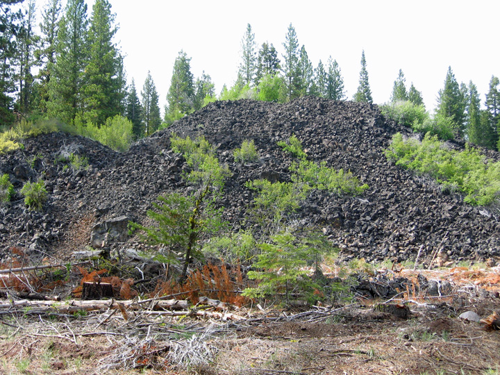
There are many areas within and outside of the park which show the results of the eruptions of ancient Mount Tehama and the other volcanoes within the area.  The above picture is within a few miles of Lassen, while the one below is about 10 miles outside of the park.

Here are two pictures of Lake Manzanita, which was formed about 350 years ago when the northeast face of Chaos Crags broke off, plummeted down into Manzanita Creek, forming a dam, and hence the lake. It is near the north entrance to Lassen, and has a huge campground around it, which is not yet open for the year.

Tomorrow we will visit Burney Falls, and other things to the north of us, then we will move to the southern entrance to Lassen.