Monday, June 5, 2017

Monticello, Utah -- In the Middle of Lots of Stuff

Mountain View RV Park, Monticello Utah

We arrived in Monticello on Thursday afternoon…and since then, we have been NO WHERE!  After 10 days of no electricity, and needing a place to have our replacement MiFi Jetpack Aircard to be delivered, we picked Mountain View RV Park in Monticello because they had a weekly rate (buy 6 nights, 7th night free at $30 per night Good Sam Discount), it was full hookups so it was long SHOWER TIME, and they were said to have good Internet…which they do.  We had a choice of close to the street, Dog Pin, and Laundry Room, or up by the office area where it would be quieter, but further away from “stuff”…we took the street.  In the picture above you can see us next to a pop-up camper.  Yes, road noise during the day, but pretty quiet at night.

Mountain View RV Park, Monticello Utah     Mountain View RV Park, Monticello Utah

During the weekday mornings and early afternoon, this is what it looks like…over 1/2 empty.  However, over the weekend it was full, and at night half the empty spaces fill up.  We called and they said, “come on in”…but reservations over the weekend during the summer are highly encouraged.  And “IF” you see a Sheriff’s Vehicle in the park, don’t worry…the male owner is a Deputy Sheriff for San Juan County, and he, his sister/sister-in-law Casey, and a number of children operate the park.  We have found it to be a great little park in a very small town, and the few bad remarks I have read about the park seem unfounded…and they have many good ones too.  It is not fancy…they don’t call it a “Resort” as others would, and they work hard to keep it up despite the MANY people who I witnessed who did not pick up dog poop in the dog enclosure, and I am sure some people take advantage of their honor system for paying for dump service, laundry and showers.  ($1 to wash, $1 to dry, per load, pay in office when you are done…not sure what the ask for to dump tanks or take showers)

Skruffy driving with Dad in Monticello Utah

So Skruffy and I went out today to get our quarterly IRS payment to the post office.  Little did I know that an hour later I would need to go back to the PO, but that is life sometimes, and more on that later.  I took this opportunity to get a few pictures of Monticello.

Mormon Church and Mormon Temple, Monticello Utah

Monticello, like many of the Utah communities, was settled by the Mormons, Monticello in 1886.  When they arrived in Monticello, other “white men” had already settled in the area, such as cattleman Patrick O'Donnell, the Kansas and New Mexico Cattle and Land Company, operated by Edmund and Harold Carlisle, was located a few miles north of what is now Monticello, and the L.C. outfit was headquartered in the South Fork of Montezuma Canyon.  Regardless, some Mormon families were sent to Monticello to start a new community.  In 1888, the name Monticello was adopted by the people in honor of Thomas Jefferson’s estate in Virginia.  Farming and Uranium mining have been the foundation of economy, and lately tourism has played a greater and greater part of the economy.  The above picture is one of their Church Buildings next to one of their smaller Temples.

7-11 Shell Station and Propane, Monticello Utah    Blue Mountain Foods Grocery,  Monticello Utah  
Trading Post, Monticello Utah 
BLM Office,  Monticello Utah     Monticello Public Library, Monticello Utah
   
Monticello, which has a population of nearly 2,000 people, does have the “necessities” of life.  Upper left picture is a 7-11/Shell Station, and the ONLY place to get Propane for your Motorhome.  Upper right is the Blue Mountain Foods grocery store (closed on Sundays).  The middle picture is a typical tourist place, of which these are all over the route from Flagstaff through Moab..this one is here in Monticello.  Bottom left is the BLM office, for those who want information about free camping or inexpensive BLM campgrounds in the area of Southeast Utah, and the bottom right is the Monticello Public Library.

Visitor's Center, Monticello, Utah     San Juan County Building, Monticello, Utah
RV parking behind post office, Monticello, Utah

There is a Visitor’s Center (upper left), the County Administration Building since it is the county seat for San Juan County, and plenty of room for RV day parking (lots of BLM land outside of town if you want to boondock).

Peace Tree Juice Cafe (known for good natural foods and free range beef/chicken), Monticello Utah
PJ's Restuarant (known for good burgers), Monticello Utah     R & F Restaurant, Monticello Utah

These are the main three restaurants, outside of the pizza and Mexican joints in town.  The upper picture is the Peace Tree Juice Cafe, of which there are two locations, Monticello and Moab and is the newer of the three restaurants, and within walking distance to the RV Park (2 blocks away).   We have not eaten out at all yet, but I do hope to give the Peace Tree a try before we leave.

Not shown are the numerous small motels and Inns, Napa Autoparts, Napa Repair Center (and other vehicle repair places), large True Value Hardware Store, other gas stations and small stores, laundromat, etc.  What they don't have is a Mall, a Walmart, a movie theater...stuff like that.  Small town, small town attitude, small town appeal. 

San Juan County is Utah’s largest county, and Blanding, 25 miles to the south, is the largest city in the county…but Monticello is more centralized to reach more National Parks/Monuments/Points of Interest such as Arches National Park to the North, Canyon Lands National Park to the North-Northwest, Natural Bridges to the Southwest, Goosenecks State Park and Monument Valley to the South, Mesa Verde National Park and Canyons of the Ancients National Monument to the Southeast.  I read a blog yesterday in which a young family came to Monticello, stayed in a Motel for five days, and visited all of these places, and a few more, during their five day stay.


FedEx tracking for Verizon Aircard Replacement


As promised, our Verizon Aircard replacement was delivered today.  I paid $6.99 to have it here in two work days just to be sure we got it before we leave on Thursday.  By Friday night it was in Albuquerque, where it stayed until Monday morning when it was sent to Durango Colorado, and then out for delivery by 10:37.  Not sure where we were going to be on the “stops”, but I told Marcia that it could not be here any earlier than 12:00 noon….and at 12:10 I saw it pull into the park.  SWEET.  Of course, now I am afraid to plug the antenna into it...


Verizon Notice


Ok, so I unpacked it, following their directions not to rip open the box, the packaging the device came in, etc. because we have to send this back.  It comes without a back, without a battery…you use the ones from the defective device.  I take the SIM card out of the old, put in the new, insert the battery, put on the back, and bingo, we are back in business.  I put the broken antenna piece, about the size of a small bean, in plastic and tape it where the battery normally goes, and put the defective device in the packaging they new one came in, and back into the FedEx box.  I look at the return postage and it says, “UPS”…hmmm, I don’t think there is a UPS place in town.  So I call up Verizon and the nice young man tells me that this is not a problem, just drop it in a USPS (Post Office) box, and that he would make a note of it in the computer.  Well, I don’t feel comfortable doing that…so I go back to the Post Office, walk inside and explain my dilemma to the nice lady behind the counter.  She says, “Well, I can take that and we will give it to the UPS driver when get here.  It was now 1 pm, and I got our taxes mailed, got our Aircard working, and got the old Aircard to the Post Office where we HOPE it gets back to Verizon.  


Mom and Dad's 69th Anniversary


I had one of those annoying “Memory” thingies pop up on Facebook AFTER I talked with Mom and Dad this morning to wish them a happy 69th anniversary.  I normally just ignore those Facebook Memory things, but this one was special…about their 67th anniversary…so I re-posted, and wished them a Happy 69th Anniversary via Facebook too.  I feel so lucky, so blessed, so happy to have mom and dad with us still…both in good health for their age, both as sharp as ever…

Thursday, June 1, 2017

Monument Valley, Goosenecks State Park

Monument Valley Area, Trail of the Ancients National Scenic Byway

Even as you are driving up to the Monument Valley area (above) …

Monument Valley Area, Trail of the Ancients National Scenic Byway    Monument Valley Area, Trail of the Ancients National Scenic Byway
Monument Valley Area, Trail of the Ancients National Scenic Byway

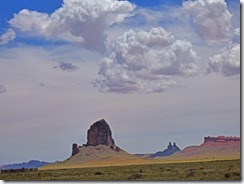
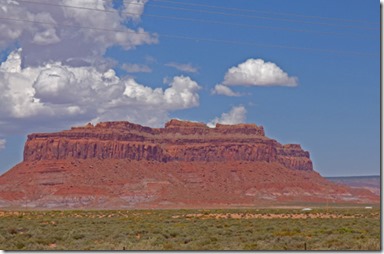
…you start to see very interesting rock/mountain formations miles before it.

(Note:  This is a VERY long post...I had over 450 pictures to sift through, and cover what was three days of driving since I have not been able to post pictures for the past two posts, and remember, clicking on a picture will bring up a larger version of that picture.)

Monument Valley Area, Trail of the Ancients National Scenic Byway    Monument Valley Area, Trail of the Ancients National Scenic Byway

We stop at the rest area/visitor’s area right off of highway 163 in front of Monument Valley…we had not eaten yet, so I cooked up some quick scrambled eggs, walked the dogs.  This visitor’s center looks like it has been converted into a center from a school.  The buildings in the upper right photo look like old classrooms, and are now places to sell “stuff”…lots and lots of “stuff” is for sale in Navajo country.  We then head east in towards Monument Valley…but the dark clouds coming in start to concern me because I had heard that to see Monument Valley, you need to drive on dirt roads.

Monument Valley Area, Trail of the Ancients National Scenic Byway    Monument Valley Area, Trail of the Ancients National Scenic Byway

I talk to the lady at the ticket gate who says that we could not drive the motorhome into the valley unless we were going to use their RV Park (no hookups and $40+ per night…yes, that is steep), and then we could only take to the RV Park..but we could drive the HHR through the Monument Valley drive.  We decide that, with the storm approaching, we would just turn around and head on to Goosenecks.

Monument Valley Area, Trail of the Ancients National Scenic Byway

As you continue along the highway, you still come upon more monument type mountains.

Monument Valley Area, Trail of the Ancients National Scenic Byway    Monument Valley Area, Trail of the Ancients National Scenic Byway

We drive on down the road, and the picture to the right is a shot looking back at all the rain we missed out on. 

Mexican Hat, Trail of the Ancients National Scenic Byway
Soon we come to Mexican Hat, Utah…a small, nothing special about it type of town which is named after this rock formation on the north side of town.  We turn onto highway 261, which has a warning about no RVs or Trucks over 40 feet or towing vehicles…but that is for 6 miles down the road…we are only going 1 mile because we then turn onto highway 316.


Goosenecks State Park, San Juan River

We finally make it to Goosenecks State Park.  This is a Utah State Park, surrounded by Bureau of Land Management (BLM) land.  Entrance into the park is $5, or $10 to stay the night…no hookups, but a great view.  That is the San Juan River which runs through the canyon, forming many Gooseneck looking features as is winds around and around these bluffs.

Goosenecks State Park, San Juan River

Of course, we spend the night.  Our camping spot looks right out over the cliff into the river canyon.  We are parked well enough away that it is not a scary thing to do, and gives you great views out the front windows which we don’t even cover up for the night,

Goosenecks State Park, San Juan River

Marcia is beat and takes a nap…I take a drive.  There is a dirt road which continues along the left rim as you face the river…and this is where I take this shot…and shortly after, I hit a rock turning around to head back and there goes our load muffler sound…same sound we just fixed back in Florida after our last trip. 

Skruffy at Goosenecks State Park, San Juan River
Bubba at Goosenecks State Park, San Juan River    Skruffy at Goosenecks State Park, San Juan River

Skruffy likes the fact the neighbors are far away…and both her and Bubba are unsure of that drop off to the river right in front of the motorhome.

Sunset Goosenecks State Park, San Juan River

The sun goes down…a storm rocks and rolls us for about an hour, but by 10 pm things have settled down, and we are out for the night.

Monument Valley from Goosenecks State Park, San Juan River

Marcia is up first, and finds the morning sun lighting up the mountains of Monument Valley to the south.  We both really enjoyed Goosenecks State Park.  I got up around 3:30 and noticed many stars shinning bright in the sky…but did not see a moon.  It was so quiet all night long.  (Quiet until I start up the car to hook it up to the motorhome that is….)  There are so many photo opportunities at Goosenecks, and as the sun changes position, and clouds come and go, it puts everything into a different perspective.

Goosenecks Area, Trail of the Ancients National Scenic Byway

As we leave Goosenecks, we see this pyramid formation (above) off to the west, towards Natural Bridges area.  IF we took a left leaving the park, we would hit very steep switchbacks as it traverses the Moki Dugway.  Much of the roads we traveled since we passed Cameron have been part of the Trail of the Ancients, a National Scenic Byway.  Mostly Navajo lands, but also some Hopi lands too.

Valley of the Gods Area, Trail of the Ancients National Scenic Byway   Valley of the Gods Area, Trail of the Ancients National Scenic BywayValley of the Gods Area, Trail of the Ancients National Scenic Byway     Valley of the Gods Area, Trail of the Ancients National Scenic Byway

And as we travel north along highway 163, we see more and more formations to our west…and the sign saying “Valley of the Gods”.  There is a dirt road which travels around 20 miles through the Valley of the Gods…all dirt road, many boondocking areas.  That “was” something I was hoping on doing…driving into the Valley of the Gods, and perhaps we still will…but first I had better see how bad the car is.  Perhaps it is just a small hole that can patched up…but my thoughts are that it is the same thing we faced last year.

Bluff Utah Area, Trail of the Ancients National Scenic Byway
Bluff Utah Area, Trail of the Ancients National Scenic Byway      Bluff Utah Area, Trail of the Ancients National Scenic Byway

As we come up to Bluff Utah, the rock formations change shape and color.  I have never been to this area of Utah, and it is just wonderful.  The good thing…we are going to stay in Monticello Utah for a week at the Mountain View RV Park, just under $230 for the week, full hookups, with lots of cable TV too, but like most parks, it comes in snowy.  The great thing, fast Internet…because yesterday I pulled the antenna cord out of our new Verizon Jet Pack…and the little post you plug into came out of the Jetpack…which is part of the antenna…which means the it is broken.  The good news…Verizon is sending another one here to the park, should be here on Monday.  The other good news, from here we plan to visit Moab again, visit Natural Bridges, do laundry, and decide where to go from here.